Santo Tomás Chiconautla geodata
Santo Tomás Chiconautla (State of Mexico) is a populated place; located in Mexico in America/Mexico_City (GMT-6) time zone. With population of 7,844 people, there are 1193 cities with bigger population in this country. Compared to other cities in Mexico, 51.1% of cities are located further ↑North; 50% of cities are located further ←West and 84.5% of cities have lower elevation than Santo Tomás Chiconautla. Note1
Current local time in Santo Tomás Chiconautla:
04:46 PM, TuesdayDifference from your time zone: hours


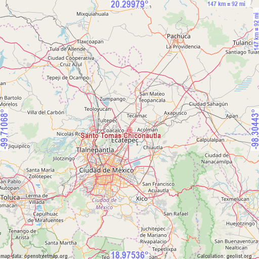
Santo Tomás Chiconautla GPS coordinates[2]
19° 38' 20.184" North, 99° 0' 27.18" West
| Map corner | latitude | longitude |
|---|---|---|
| Upper-left | 20.29979°, | -99.71068° |
| Center: | 19.63894°, | -99.00755° |
| Lower-right: | 18.97536°, | -98.30443° |
| Map W x H: | 147.3×147.3 km | = 91.5×91.5mi |
| max Lat: | 32.7° ⇑51.1% North |
| Santo Tomás Chiconautla: | 19.63894° |
| min Lat: | ⇓48.9% South 14.53588° |
| min Long | Santo Tomás Ch | max Long |
| -117.105° | -99.00755° | -86.73105° |
| W 50%⇐ | ⇒50% E |
Elevation
Elevation of Santo Tomás Chiconautla is 2251 m = 7385 ft, and this is 997.3 m = 3272 ft above average elevation for this country.
| Max E: |
3497 m = 11473 ft | 15.5% |
| Santo Tomás Chiconautla | 2251 m 7385 ft | |
| Avg. | 1253.7 m = 4113 ft | |
Min E: |
-1 m = -3 ft | 84.5% |
See also: Mexico elevation on elevation.city.
Geographical zone
Santo Tomás Chiconautla is located in North Torrid zone (between Equator and Tropic of Cancer). Distance of this Northern Tropic circle is 422.3 km =262.4 mi to North.| Distance of | km | miles | from Santo Tomás Chiconautla |
|---|---|---|---|
| North Pole | 7823.4 | 4861.2 | to North |
| Arctic Circle | 5217.5 | 3242 | to North |
| Tropic Cancer | 422.3 | 262.4 | to North |
| Equator | 2183.6 | 1356.8 | to South |


Nearby cities:
15 places around Santo Tomás Chiconautla: (largest is in red/bold)
• Alborada Jaltenco
6.9 km =4.3 mi,  291°
291°
• Colonia Tezontla
3.9 km =2.4 mi,  23°
23°
• Colonia el Salado
6.4 km =4 mi,  164°
164°
• Colonia la Asunción
8.3 km =5.2 mi,  314°
314°
• Ecatepec de Morelos
6.7 km =4.2 mi,  235°
235°
• Granjas Ampliación Santa Rosa
6.7 km =4.2 mi,  140°
140°
• Nueva Santa Rosa
7.4 km =4.6 mi, 137°
• Ojo de Agua
4.6 km =2.9 mi,  356°
356°
• Prados de San Juan
3.4 km =2.1 mi,  88°
88°
• San Martín Azcatepec
6.4 km =4 mi,  34°
34°
• San Pablo Tecalco
6.4 km =4 mi,  53°
53°
• Tepexpan
8 km =5 mi,  110°
110°
• Tequisistlán
8.4 km =5.2 mi,  124°
124°
• Tequisistlán Primero
6.8 km =4.2 mi,  129°
129°
• Tonanitla
7.3 km =4.5 mi,  318°
318°
Sources, notices
• [Note1] Compared only with cities in Mexico existing in our database
• [Src1] Map data: © OpenStreetMap contributors (CC-BY-SA)
• [Src2] Other city data from geonames.org with taken over terms of usage.
• [Src3] Geographical zone / Annual Mean Temperature by Robert A. Rohde @ Wikipedia
