Prados de San Juan geodata
Prados de San Juan (State of Mexico) is a populated place; located in Mexico in America/Mexico_City (GMT-6) time zone. With population of 3,081 people, there are 2925 cities with bigger population in this country. Compared to other cities in Mexico, 51.1% of cities are located further ↑North; 50.6% of cities are located further ←West and 89.4% of cities have lower elevation than Prados de San Juan. Note1


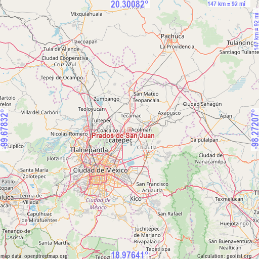
Prados de San Juan GPS coordinates[2]
19° 38' 23.928" North, 98° 58' 30.684" West
| Map corner | latitude | longitude |
|---|---|---|
| Upper-left | 20.30082°, | -99.67832° |
| Center: | 19.63998°, | -98.97519° |
| Lower-right: | 18.97641°, | -98.27207° |
| Map W x H: | 147.3×147.3 km | = 91.5×91.5mi |
| max Lat: | 32.7° ⇑51.1% North |
| Prados de San Juan: | 19.63998° |
| min Lat: | ⇓48.9% South 14.53588° |
| min Long | Prados de San J | max Long |
| -117.105° | -98.97519° | -86.73105° |
| W 50.6%⇐ | ⇒49.4% E |
Elevation
Elevation of Prados de San Juan is 2385 m = 7825 ft, and this is 1131.3 m = 3712 ft above average elevation for this country.
| Max E: |
3497 m = 11473 ft | 10.6% |
| Prados de San Juan | 2385 m 7825 ft | |
| Avg. | 1253.7 m = 4113 ft | |
Min E: |
-1 m = -3 ft | 89.4% |
See also: Mexico elevation on elevation.city.
Geographical zone
Prados de San Juan is located in North Torrid zone (between Equator and Tropic of Cancer). Distance of this Northern Tropic circle is 422.2 km =262.3 mi to North.| Distance of | km | miles | from Prados de San Juan |
|---|---|---|---|
| North Pole | 7823.3 | 4861.2 | to North |
| Arctic Circle | 5217.4 | 3241.9 | to North |
| Tropic Cancer | 422.2 | 262.3 | to North |
| Equator | 2183.8 | 1356.9 | to South |


Nearby cities:
15 places around Prados de San Juan: (largest is in red/bold)
• Acolman de Netzahualcóyotl
7.1 km =4.4 mi,  90°
90°
• Colonia Tezontla
3.9 km =2.4 mi,  331°
331°
• Colonia el Salado
6.5 km =4 mi,  195°
195°
• Granjas Ampliación Santa Rosa
5.3 km =3.3 mi,  170°
170°
• Nueva Santa Rosa
5.8 km =3.6 mi,  163°
163°
• Ojo de Agua
5.8 km =3.6 mi,  320°
320°
• San Marcos Nepantla
5.6 km =3.5 mi,  54°
54°
• San Martín Azcatepec
5.2 km =3.2 mi,  2°
2°
• San Pablo Tecalco
4.1 km =2.5 mi,  25°
25°
• Santa Catarina
5.1 km =3.2 mi, 94°
• Santa Isabel Ixtapan
6.6 km =4.1 mi,  153°
153°
• Santo Tomás Chiconautla
3.4 km =2.1 mi,  268°
268°
• Tepexpan
5 km =3.1 mi,  125°
125°
• Tequisistlán
6 km =3.7 mi,  143°
143°
• Tequisistlán Primero
4.8 km =3 mi, 156°
Sources, notices
• [Note1] Compared only with cities in Mexico existing in our database
• [Src1] Map data: © OpenStreetMap contributors (CC-BY-SA)
• [Src2] Other city data from geonames.org with taken over terms of usage.
• [Src3] Geographical zone / Annual Mean Temperature by Robert A. Rohde @ Wikipedia
