Tenayuca geodata
Tenayuca (Jalisco) is a populated place; located in Mexico in America/Mexico_City (GMT-6) time zone. With population of 1,901 people, there are 4574 cities with bigger population in this country. Compared to other cities in Mexico, 81.4% of cities are located further ↓South; 84.7% of cities are located further →East and 66.2% of cities have lower elevation than Tenayuca. Note1


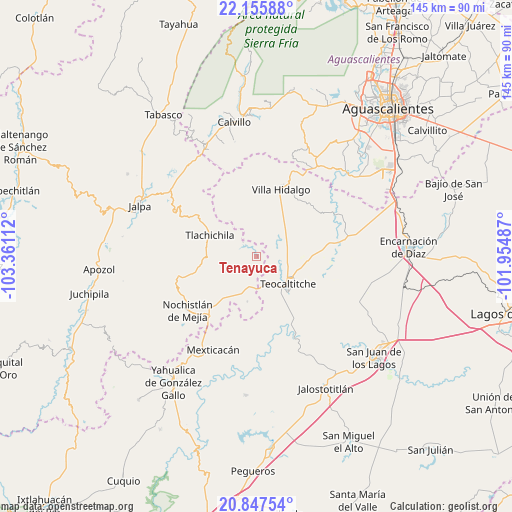
Tenayuca GPS coordinates[2]
21° 30' 11.448" North, 102° 39' 28.764" West
| Map corner | latitude | longitude |
|---|---|---|
| Upper-left | 22.15588°, | -103.36112° |
| Center: | 21.50318°, | -102.65799° |
| Lower-right: | 20.84754°, | -101.95487° |
| Map W x H: | 145.5×145.5 km | = 90.4×90.4mi |
| max Lat: | 32.7° ⇑18.6% North |
| Tenayuca: | 21.50318° |
| min Lat: | ⇓81.4% South 14.53588° |
| min Long | Tenayuca | max Long |
| -117.105° | -102.65799° | -86.73105° |
| W 15.3%⇐ | ⇒84.7% E |
Elevation
Elevation of Tenayuca is 1855 m = 6086 ft, and this is 601.3 m = 1973 ft above average elevation for this country.
| Max E: |
3497 m = 11473 ft | 33.8% |
| Tenayuca | 1855 m 6086 ft | |
| Avg. | 1253.7 m = 4113 ft | |
Min E: |
-1 m = -3 ft | 66.2% |
See also: Mexico elevation on elevation.city.
Geographical zone
Tenayuca is located in North Torrid zone (between Equator and Tropic of Cancer). Distance of this Northern Tropic circle is 215 km =133.6 mi to North.| Distance of | km | miles | from Tenayuca |
|---|---|---|---|
| North Pole | 7616.1 | 4732.4 | to North |
| Arctic Circle | 5010.2 | 3113.2 | to North |
| Tropic Cancer | 215 | 133.6 | to North |
| Equator | 2390.9 | 1485.6 | to South |


Nearby cities:
15 places around Tenayuca: (largest is in red/bold)
• Apulco
13 km =8.1 mi,  191°
191°
• Belén del Refugio
23.2 km =14.4 mi,  82°
82°
• Colonia Lindavista
25.3 km =15.7 mi,  235°
235°
• Colonia Lomas del Refugio
23.4 km =14.5 mi,  228°
228°
• El Rosario
14.9 km =9.3 mi,  320°
320°
• Huejotitlán
12.7 km =7.9 mi,  170°
170°
• José de Jesús Aguirre
19.4 km =12.1 mi, 83°
• Mechoacanejo
7.6 km =4.7 mi,  57°
57°
• Mexticacán
29.3 km =18.2 mi,  205°
205°
• Nochistlán de Mejía
24.8 km =15.4 mi, 231°
• San Gaspar de los Reyes
28.6 km =17.8 mi,  145°
145°
• Teocaltiche
11.6 km =7.2 mi,  131°
131°
• Tepusco
13.5 km =8.4 mi,  25°
25°
• Tlachichila
14.6 km =9.1 mi,  294°
294°
• Villa Hidalgo
20.5 km =12.7 mi,  20°
20°
Sources, notices
• [Note1] Compared only with cities in Mexico existing in our database
• [Src1] Map data: © OpenStreetMap contributors (CC-BY-SA)
• [Src2] Other city data from geonames.org with taken over terms of usage.
• [Src3] Geographical zone / Annual Mean Temperature by Robert A. Rohde @ Wikipedia
