Belén del Refugio geodata
Belén del Refugio (Jalisco) is a populated place; located in Mexico in America/Mexico_City (GMT-6) time zone. With population of 2,404 people, there are 3671 cities with bigger population in this country. Compared to other cities in Mexico, 81.6% of cities are located further ↓South; 83.7% of cities are located further →East and 60% of cities have lower elevation than Belén del Refugio. Note1


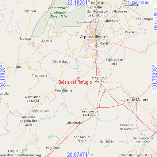
Belén del Refugio GPS coordinates[2]
21° 31' 48.828" North, 102° 26' 6.54" West
| Map corner | latitude | longitude |
|---|---|---|
| Upper-left | 22.18281°, | -103.13828° |
| Center: | 21.53023°, | -102.43515° |
| Lower-right: | 20.87471°, | -101.73203° |
| Map W x H: | 145.4×145.4 km | = 90.3×90.3mi |
| max Lat: | 32.7° ⇑18.4% North |
| Belén del Refugio: | 21.53023° |
| min Lat: | ⇓81.6% South 14.53588° |
| min Long | Belén del Refu | max Long |
| -117.105° | -102.43515° | -86.73105° |
| W 16.3%⇐ | ⇒83.7% E |
Elevation
Elevation of Belén del Refugio is 1726 m = 5663 ft, and this is 472.3 m = 1550 ft above average elevation for this country.
| Max E: |
3497 m = 11473 ft | 40% |
| Belén del Refugio | 1726 m 5663 ft | |
| Avg. | 1253.7 m = 4113 ft | |
Min E: |
-1 m = -3 ft | 60% |
See also: Mexico elevation on elevation.city.
Geographical zone
Belén del Refugio is located in North Torrid zone (between Equator and Tropic of Cancer). Distance of this Northern Tropic circle is 212 km =131.7 mi to North.| Distance of | km | miles | from Belén del Refugio |
|---|---|---|---|
| North Pole | 7613.1 | 4730.6 | to North |
| Arctic Circle | 5007.2 | 3111.3 | to North |
| Tropic Cancer | 212 | 131.7 | to North |
| Equator | 2393.9 | 1487.5 | to South |


Nearby cities:
15 places around Belén del Refugio: (largest is in red/bold)
• Buenavista de Peñuelas
25.3 km =15.7 mi,  34°
34°
• Centro de Arriba
23.3 km =14.5 mi,  343°
343°
• Cieneguilla
22.7 km =14.1 mi,  355°
355°
• El Salvador
20 km =12.4 mi,  66°
66°
• El Tanque de los Jiménez
20.8 km =12.9 mi,  17°
17°
• Encarnación de Díaz
20.2 km =12.6 mi,  91°
91°
• José de Jesús Aguirre
3.9 km =2.4 mi,  255°
255°
• Mechoacanejo
16.7 km =10.4 mi,  273°
273°
• San Antonio de Peñuelas
21.3 km =13.2 mi,  40°
40°
• Santa María Transpontina
22.4 km =13.9 mi,  124°
124°
• Santa María de Enmedio
25.2 km =15.7 mi, 119°
• Tenayuca
23.2 km =14.4 mi, 262°
• Teocaltiche
17.9 km =11.1 mi,  233°
233°
• Tepusco
19.6 km =12.2 mi,  298°
298°
• Villa Hidalgo
22.7 km =14.1 mi,  315°
315°
Sources, notices
• [Note1] Compared only with cities in Mexico existing in our database
• [Src1] Map data: © OpenStreetMap contributors (CC-BY-SA)
• [Src2] Other city data from geonames.org with taken over terms of usage.
• [Src3] Geographical zone / Annual Mean Temperature by Robert A. Rohde @ Wikipedia
