Apulco geodata
Apulco (Zacatecas) is a seat of a second-order administrative division; located in Mexico in America/Mexico_City (GMT-6) time zone. With population of 1,526 people, there are 5654 cities with bigger population in this country. Compared to other cities in Mexico, 80.8% of cities are located further ↓South; 84.7% of cities are located further →East and 63.7% of cities have lower elevation than Apulco. Note1


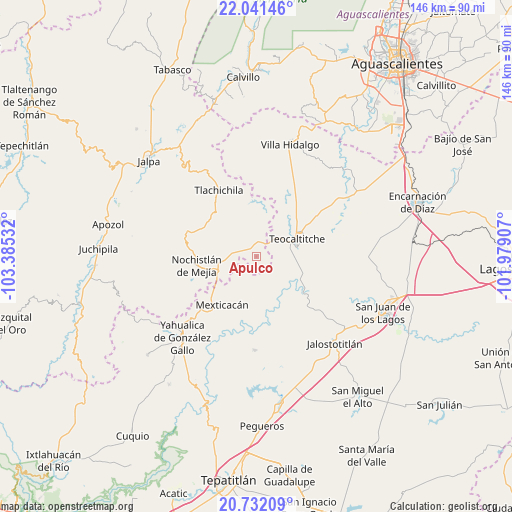
Apulco GPS coordinates[2]
21° 23' 17.664" North, 102° 40' 55.884" West
| Map corner | latitude | longitude |
|---|---|---|
| Upper-left | 22.04146°, | -103.38532° |
| Center: | 21.38824°, | -102.68219° |
| Lower-right: | 20.73209°, | -101.97907° |
| Map W x H: | 145.6×145.6 km | = 90.5×90.5mi |
| max Lat: | 32.7° ⇑19.2% North |
| Apulco: | 21.38824° |
| min Lat: | ⇓80.8% South 14.53588° |
| min Long | Apulco | max Long |
| -117.105° | -102.68219° | -86.73105° |
| W 15.3%⇐ | ⇒84.7% E |
Elevation
Elevation of Apulco is 1795 m = 5889 ft, and this is 541.3 m = 1776 ft above average elevation for this country.
| Max E: |
3497 m = 11473 ft | 36.3% |
| Apulco | 1795 m 5889 ft | |
| Avg. | 1253.7 m = 4113 ft | |
Min E: |
-1 m = -3 ft | 63.7% |
See also: Mexico elevation on elevation.city.
Geographical zone
Apulco is located in North Torrid zone (between Equator and Tropic of Cancer). Distance of this Northern Tropic circle is 227.8 km =141.5 mi to North.| Distance of | km | miles | from Apulco |
|---|---|---|---|
| North Pole | 7628.9 | 4740.4 | to North |
| Arctic Circle | 5023 | 3121.1 | to North |
| Tropic Cancer | 227.8 | 141.5 | to North |
| Equator | 2378.1 | 1477.7 | to South |


Nearby cities:
15 places around Apulco: (largest is in red/bold)
• Cañadas de Obregón
26.6 km =16.5 mi,  181°
181°
• Colonia Lindavista
18.4 km =11.4 mi,  265°
265°
• Colonia Lomas del Refugio
15.2 km =9.4 mi,  259°
259°
• Daniel Camarena
22.4 km =13.9 mi, 257°
• El Rosario
25.3 km =15.7 mi,  344°
344°
• Huejotitlán
4.7 km =2.9 mi,  86°
86°
• José de Jesús Aguirre
26.4 km =16.4 mi,  55°
55°
• Mechoacanejo
19.1 km =11.9 mi,  27°
27°
• Mexticacán
17 km =10.6 mi,  216°
216°
• Nochistlán de Mejía
17.2 km =10.7 mi, 261°
• San Gaspar de los Reyes
21.5 km =13.4 mi,  120°
120°
• Tenayuca
13 km =8.1 mi,  11°
11°
• Teocaltiche
12.3 km =7.6 mi,  65°
65°
• Tepusco
26.3 km =16.3 mi,  18°
18°
• Tlachichila
21.7 km =13.5 mi,  330°
330°
Sources, notices
• [Note1] Compared only with cities in Mexico existing in our database
• [Src1] Map data: © OpenStreetMap contributors (CC-BY-SA)
• [Src2] Other city data from geonames.org with taken over terms of usage.
• [Src3] Geographical zone / Annual Mean Temperature by Robert A. Rohde @ Wikipedia
