Ramón López Velarde geodata
Ramón López Velarde (Zacatecas) is a populated place; located in Mexico in America/Mexico_City (GMT-6) time zone. With population of 541 people, there are 15692 cities with bigger population in this country. Compared to other cities in Mexico, 88.5% of cities are located further ↓South; 85.4% of cities are located further →East and 81.2% of cities have lower elevation than Ramón López Velarde. Note1


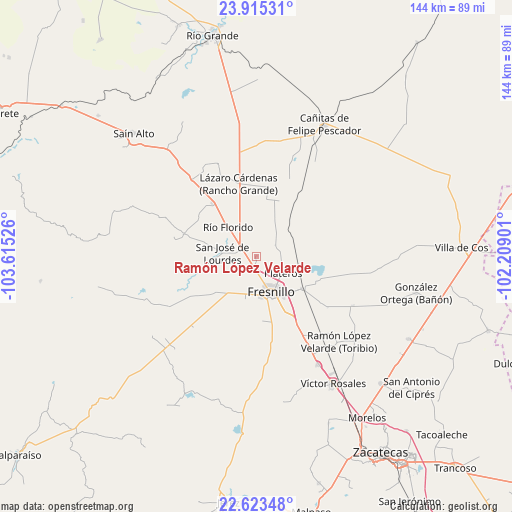
Ramón López Velarde GPS coordinates[2]
23° 16' 15.456" North, 102° 54' 43.668" West
| Map corner | latitude | longitude |
|---|---|---|
| Upper-left | 23.91531°, | -103.61526° |
| Center: | 23.27096°, | -102.91213° |
| Lower-right: | 22.62348°, | -102.20901° |
| Map W x H: | 143.6×143.6 km | = 89.2×89.2mi |
| max Lat: | 32.7° ⇑11.5% North |
| Ramón López Velarde: | 23.27096° |
| min Lat: | ⇓88.5% South 14.53588° |
| min Long | Ramón López V | max Long |
| -117.105° | -102.91213° | -86.73105° |
| W 14.6%⇐ | ⇒85.4% E |
Elevation
Elevation of Ramón López Velarde is 2167 m = 7110 ft, and this is 913.3 m = 2996 ft above average elevation for this country.
| Max E: |
3497 m = 11473 ft | 18.8% |
| Ramón López Velarde | 2167 m 7110 ft | |
| Avg. | 1253.7 m = 4113 ft | |
Min E: |
-1 m = -3 ft | 81.2% |
See also: Mexico elevation on elevation.city.
Geographical zone
Ramón López Velarde is located in North Torrid zone (between Equator and Tropic of Cancer). Distance of this Northern Tropic circle is 18.4 km =11.4 mi to North.| Distance of | km | miles | from Ramón López Velarde |
|---|---|---|---|
| North Pole | 7419.6 | 4610.3 | to North |
| Arctic Circle | 4813.7 | 2991.1 | to North |
| Tropic Cancer | 18.4 | 11.4 | to North |
| Equator | 2587.5 | 1607.8 | to South |


Nearby cities:
15 places around Ramón López Velarde: (largest is in red/bold)
• Altamira
14.5 km =9 mi,  328°
328°
• Carrillo
10.7 km =6.6 mi,  225°
225°
• Colonia Plenitud
17.2 km =10.7 mi,  255°
255°
• Colonia Santa Anita
15.5 km =9.6 mi,  107°
107°
• Estación San José
15.8 km =9.8 mi,  124°
124°
• Fraccionamiento San Felipe
14.7 km =9.1 mi,  133°
133°
• Fresnillo
10.8 km =6.7 mi,  157°
157°
• José María Morelos
11.9 km =7.4 mi,  298°
298°
• Laguna Seca
14.1 km =8.8 mi, 122°
• México Nuevo Uno (México Nuevo)
14.5 km =9 mi, 226°
• Plateros
8.5 km =5.3 mi, 123°
• Río Florido
11.4 km =7.1 mi,  315°
315°
• San Gabriel
8.7 km =5.4 mi,  291°
291°
• San Ignacio
10.5 km =6.5 mi,  306°
306°
• San Jose de Lourdes
10 km =6.2 mi,  273°
273°
Sources, notices
• [Note1] Compared only with cities in Mexico existing in our database
• [Src1] Map data: © OpenStreetMap contributors (CC-BY-SA)
• [Src2] Other city data from geonames.org with taken over terms of usage.
• [Src3] Geographical zone / Annual Mean Temperature by Robert A. Rohde @ Wikipedia
