Ignacio Allende geodata
Ignacio Allende (Chihuahua) is a populated place; located in Mexico in America/Chihuahua (GMT-6) time zone. With population of 935 people, there are 9320 cities with bigger population in this country. Compared to other cities in Mexico, 98.3% of cities are located further ↓South; 95.3% of cities are located further →East and 76.5% of cities have lower elevation than Ignacio Allende. Note1


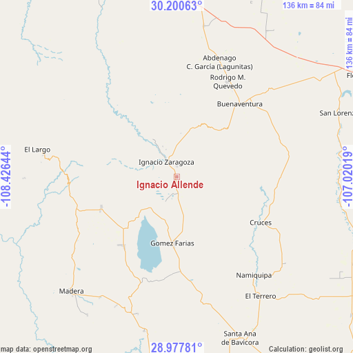
Ignacio Allende GPS coordinates[2]
29° 35' 27.852" North, 107° 43' 23.916" West
| Map corner | latitude | longitude |
|---|---|---|
| Upper-left | 30.20063°, | -108.42644° |
| Center: | 29.59107°, | -107.72331° |
| Lower-right: | 28.97781°, | -107.02019° |
| Map W x H: | 136×136 km | = 84.5×84.5mi |
| max Lat: | 32.7° ⇑1.7% North |
| Ignacio Allende: | 29.59107° |
| min Lat: | ⇓98.3% South 14.53588° |
| min Long | Ignacio Allende | max Long |
| -117.105° | -107.72331° | -86.73105° |
| W 4.7%⇐ | ⇒95.3% E |
Elevation
Elevation of Ignacio Allende is 2058 m = 6752 ft, and this is 804.3 m = 2639 ft above average elevation for this country.
| Max E: |
3497 m = 11473 ft | 23.5% |
| Ignacio Allende | 2058 m 6752 ft | |
| Avg. | 1253.7 m = 4113 ft | |
Min E: |
-1 m = -3 ft | 76.5% |
See also: Mexico elevation on elevation.city.
Geographical zone
Ignacio Allende is located in North temperate zone (between Tropic of Cancer and the Arctic Circle). Distance of this Northern Tropic circle is 684.3 km =425.2 mi to South.| Distance of | km | miles | from Ignacio Allende |
|---|---|---|---|
| North Pole | 6716.8 | 4173.6 | to North |
| Arctic Circle | 4111 | 2554.5 | to North |
| Tropic Cancer | 684.3 | 425.2 | to South |
| Equator | 3290.2 | 2044.4 | to South |


Nearby cities:
15 places around Ignacio Allende: (largest is in red/bold)
• Abdenago C. García
47.3 km =29.4 mi,  20°
20°
• Benito Juárez
27.1 km =16.8 mi,  309°
309°
• Francisco I. Madero
15 km =9.3 mi,  328°
328°
• Gómez Farías
25.8 km =16 mi,  183°
183°
• Ignacio Zaragoza
6.9 km =4.3 mi, 325°
• La Pinta
40.2 km =25 mi,  172°
172°
• Las Cruces
36.8 km =22.9 mi,  118°
118°
• Las Varas (Estación Babícora)
31.7 km =19.7 mi,  247°
247°
• Mesa del Huracán
51.8 km =32.2 mi,  279°
279°
• Namiquipa
48.2 km =30 mi,  141°
141°
• Nicolas Bravo
33.4 km =20.8 mi,  217°
217°
• Peña Blanca
33.5 km =20.8 mi, 178°
• Rodrígo M. Quevedo
41.5 km =25.8 mi,  28°
28°
• San Buenaventura
37.8 km =23.5 mi,  42°
42°
• San José Bavícora
38 km =23.6 mi, 183°
Sources, notices
• [Note1] Compared only with cities in Mexico existing in our database
• [Src1] Map data: © OpenStreetMap contributors (CC-BY-SA)
• [Src2] Other city data from geonames.org with taken over terms of usage.
• [Src3] Geographical zone / Annual Mean Temperature by Robert A. Rohde @ Wikipedia
