Las Cruces geodata
Las Cruces (Chihuahua) is a populated place; located in Mexico in America/Chihuahua (GMT-6) time zone. With population of 1,206 people, there are 7208 cities with bigger population in this country. Compared to other cities in Mexico, 98.3% of cities are located further ↓South; 94.8% of cities are located further →East and 61.6% of cities have lower elevation than Las Cruces. Note1


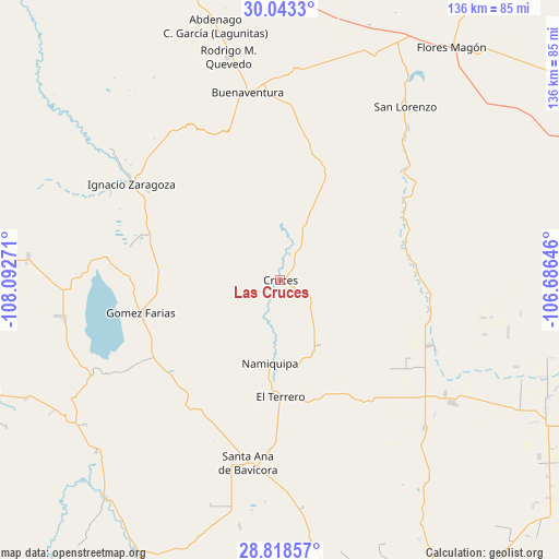
Las Cruces GPS coordinates[2]
29° 25' 58.008" North, 107° 23' 22.488" West
| Map corner | latitude | longitude |
|---|---|---|
| Upper-left | 30.0433°, | -108.09271° |
| Center: | 29.43278°, | -107.38958° |
| Lower-right: | 28.81857°, | -106.68646° |
| Map W x H: | 136.2×136.2 km | = 84.6×84.6mi |
| max Lat: | 32.7° ⇑1.7% North |
| Las Cruces: | 29.43278° |
| min Lat: | ⇓98.3% South 14.53588° |
| min Long | Las Cruces | max Long |
| -117.105° | -107.38958° | -86.73105° |
| W 5.2%⇐ | ⇒94.8% E |
Elevation
Elevation of Las Cruces is 1751 m = 5745 ft, and this is 497.3 m = 1632 ft above average elevation for this country.
| Max E: |
3497 m = 11473 ft | 38.4% |
| Las Cruces | 1751 m 5745 ft | |
| Avg. | 1253.7 m = 4113 ft | |
Min E: |
-1 m = -3 ft | 61.6% |
See also: Mexico elevation on elevation.city.
Geographical zone
Las Cruces is located in North temperate zone (between Tropic of Cancer and the Arctic Circle). Distance of this Northern Tropic circle is 666.7 km =414.3 mi to South.| Distance of | km | miles | from Las Cruces |
|---|---|---|---|
| North Pole | 6734.4 | 4184.6 | to North |
| Arctic Circle | 4128.6 | 2565.4 | to North |
| Tropic Cancer | 666.7 | 414.3 | to South |
| Equator | 3272.6 | 2033.5 | to South |


Nearby cities:
15 places around Las Cruces: (largest is in red/bold)
• El Molino
26.8 km =16.7 mi,  183°
183°
• El Terrero
27.9 km =17.3 mi, 179°
• Francisco I. Madero
50.4 km =31.3 mi,  307°
307°
• Gómez Farías
34.9 km =21.7 mi,  256°
256°
• Ignacio Allende
36.8 km =22.9 mi,  298°
298°
• Ignacio Zaragoza
43.1 km =26.8 mi, 302°
• Independencia
40.7 km =25.3 mi,  201°
201°
• La Pinta
35.4 km =22 mi,  230°
230°
• Lázaro Cárdenas
50.2 km =31.2 mi,  135°
135°
• Namiquipa
20.3 km =12.6 mi,  186°
186°
• Oscar Soto Maynez
45.5 km =28.3 mi, 190°
• Peña Blanca
35 km =21.7 mi,  242°
242°
• San Buenaventura
46.1 km =28.6 mi,  351°
351°
• San José Bavícora
40.2 km =25 mi, 239°
• Santa Catalina de Villela
49.2 km =30.6 mi,  124°
124°
Sources, notices
• [Note1] Compared only with cities in Mexico existing in our database
• [Src1] Map data: © OpenStreetMap contributors (CC-BY-SA)
• [Src2] Other city data from geonames.org with taken over terms of usage.
• [Src3] Geographical zone / Annual Mean Temperature by Robert A. Rohde @ Wikipedia
