Namiquipa geodata
Namiquipa (Chihuahua) is a seat of a second-order administrative division; located in Mexico in America/Chihuahua (GMT-6) time zone. With population of 1,752 people, there are 4957 cities with bigger population in this country. Compared to other cities in Mexico, 98.2% of cities are located further ↓South; 94.9% of cities are located further →East and 65.3% of cities have lower elevation than Namiquipa. Note1


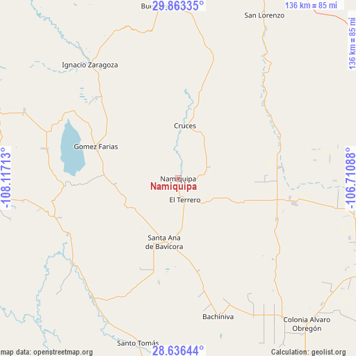
Namiquipa GPS coordinates[2]
29° 15' 6.228" North, 107° 24' 50.4" West
| Map corner | latitude | longitude |
|---|---|---|
| Upper-left | 29.86335°, | -108.11713° |
| Center: | 29.25173°, | -107.414° |
| Lower-right: | 28.63644°, | -106.71088° |
| Map W x H: | 136.4×136.4 km | = 84.8×84.8mi |
| max Lat: | 32.7° ⇑1.8% North |
| Namiquipa: | 29.25173° |
| min Lat: | ⇓98.2% South 14.53588° |
| min Long | Namiquipa | max Long |
| -117.105° | -107.414° | -86.73105° |
| W 5.1%⇐ | ⇒94.9% E |
Elevation
Elevation of Namiquipa is 1837 m = 6027 ft, and this is 583.3 m = 1914 ft above average elevation for this country.
| Max E: |
3497 m = 11473 ft | 34.7% |
| Namiquipa | 1837 m 6027 ft | |
| Avg. | 1253.7 m = 4113 ft | |
Min E: |
-1 m = -3 ft | 65.3% |
See also: Mexico elevation on elevation.city.
Geographical zone
Namiquipa is located in North temperate zone (between Tropic of Cancer and the Arctic Circle). Distance of this Northern Tropic circle is 646.6 km =401.8 mi to South.| Distance of | km | miles | from Namiquipa |
|---|---|---|---|
| North Pole | 6754.6 | 4197.1 | to North |
| Arctic Circle | 4148.7 | 2577.9 | to North |
| Tropic Cancer | 646.6 | 401.8 | to South |
| Equator | 3252.5 | 2021 | to South |


Nearby cities:
15 places around Namiquipa: (largest is in red/bold)
• Abraham González
30.7 km =19.1 mi,  182°
182°
• Benito Juárez
45.3 km =28.1 mi,  102°
102°
• El Molino
6.7 km =4.2 mi,  173°
173°
• El Terrero
8.2 km =5.1 mi,  161°
161°
• Gómez Farías
33.8 km =21 mi,  290°
290°
• Ignacio Allende
48.2 km =30 mi,  321°
321°
• Independencia
21.7 km =13.5 mi,  215°
215°
• La Pinta
25.2 km =15.7 mi,  264°
264°
• Las Cruces
20.3 km =12.6 mi,  6°
6°
• Lázaro Cárdenas
40.8 km =25.4 mi,  112°
112°
• Nicolas Bravo
51.7 km =32.1 mi,  282°
282°
• Oscar Soto Maynez
25.3 km =15.7 mi,  192°
192°
• Peña Blanca
29.1 km =18.1 mi, 278°
• San José Bavícora
32.3 km =20.1 mi,  269°
269°
• Santa Catalina de Villela
43.5 km =27 mi, 100°
Sources, notices
• [Note1] Compared only with cities in Mexico existing in our database
• [Src1] Map data: © OpenStreetMap contributors (CC-BY-SA)
• [Src2] Other city data from geonames.org with taken over terms of usage.
• [Src3] Geographical zone / Annual Mean Temperature by Robert A. Rohde @ Wikipedia
