Miguel Alemán geodata
Miguel Alemán (Sinaloa) is a populated place; located in Mexico in America/Mazatlan (GMT-7) time zone. With population of 726 people, there are 12023 cities with bigger population in this country. Compared to other cities in Mexico, 93.1% of cities are located further ↓South; 96.7% of cities are located further →East and 97% of cities have higher elevation than Miguel Alemán. Note1


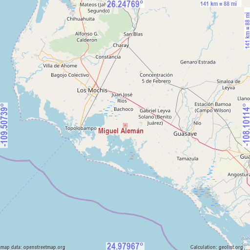
Miguel Alemán GPS coordinates[2]
25° 36' 55.296" North, 108° 48' 15.336" West
| Map corner | latitude | longitude |
|---|---|---|
| Upper-left | 26.24769°, | -109.50739° |
| Center: | 25.61536°, | -108.80426° |
| Lower-right: | 24.97967°, | -108.10114° |
| Map W x H: | 141×141 km | = 87.6×87.6mi |
| max Lat: | 32.7° ⇑6.9% North |
| Miguel Alemán: | 25.61536° |
| min Lat: | ⇓93.1% South 14.53588° |
| min Long | Miguel Alemán | max Long |
| -117.105° | -108.80426° | -86.73105° |
| W 3.3%⇐ | ⇒96.7% E |
Elevation
Elevation of Miguel Alemán is 10 m = 33 ft, and this is 1243.7 m = 4080 ft below average elevation for this country.
| Max E: |
3497 m = 11473 ft | 97% |
| Avg. | 1253.7 m = 4113 ft | |
| Miguel Alemán | 10 m = 33 ft | |
Min E: |
-1 m = -3 ft | 3% |
See also: Mexico elevation on elevation.city.
Geographical zone
Miguel Alemán is located in North temperate zone (between Tropic of Cancer and the Arctic Circle). Distance of this Northern Tropic circle is 242.2 km =150.5 mi to South.| Distance of | km | miles | from Miguel Alemán |
|---|---|---|---|
| North Pole | 7158.9 | 4448.3 | to North |
| Arctic Circle | 4553 | 2829.1 | to North |
| Tropic Cancer | 242.2 | 150.5 | to South |
| Equator | 2848.2 | 1769.8 | to South |


Nearby cities:
15 places around Miguel Alemán: (largest is in red/bold)
• Adolfo Ruiz Cortines
12.9 km =8 mi,  41°
41°
• Adolfo Ruíz Cortínes
15.9 km =9.9 mi,  19°
19°
• Bachoco
9.1 km =5.7 mi,  353°
353°
• Colonia 24 de Febrero
15.9 km =9.9 mi,  77°
77°
• Corerepe
9.1 km =5.7 mi, 81°
• Ejido Figueroa
16.5 km =10.3 mi,  64°
64°
• El Campesino
14.8 km =9.2 mi,  52°
52°
• El Caracol
14.9 km =9.3 mi,  157°
157°
• El Huitusi
12 km =7.5 mi,  167°
167°
• El Huitussi y Anexos (El Huitussito)
11.7 km =7.3 mi,  74°
74°
• Héroes Mexicanos
17.8 km =11.1 mi, 17°
• Juan José Ríos
16 km =9.9 mi, 352°
• Leyva Solano
17.5 km =10.9 mi, 72°
• Lázaro Cárdenas
16.4 km =10.2 mi,  263°
263°
• Ruiz Cortines Número Uno
18.1 km =11.2 mi, 36°
Sources, notices
• [Note1] Compared only with cities in Mexico existing in our database
• [Src1] Map data: © OpenStreetMap contributors (CC-BY-SA)
• [Src2] Other city data from geonames.org with taken over terms of usage.
• [Src3] Geographical zone / Annual Mean Temperature by Robert A. Rohde @ Wikipedia
