Corerepe geodata
Corerepe (Sinaloa) is a populated place; located in Mexico in America/Mazatlan (GMT-7) time zone. With population of 3,689 people, there are 2487 cities with bigger population in this country. Compared to other cities in Mexico, 93.2% of cities are located further ↓South; 96.6% of cities are located further →East and 97% of cities have higher elevation than Corerepe. Note1


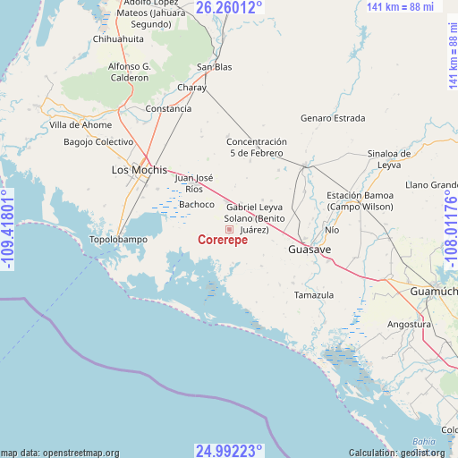
Corerepe GPS coordinates[2]
25° 37' 40.296" North, 108° 42' 53.568" West
| Map corner | latitude | longitude |
|---|---|---|
| Upper-left | 26.26012°, | -109.41801° |
| Center: | 25.62786°, | -108.71488° |
| Lower-right: | 24.99223°, | -108.01176° |
| Map W x H: | 141×141 km | = 87.6×87.6mi |
| max Lat: | 32.7° ⇑6.8% North |
| Corerepe: | 25.62786° |
| min Lat: | ⇓93.2% South 14.53588° |
| min Long | Corerepe | max Long |
| -117.105° | -108.71488° | -86.73105° |
| W 3.4%⇐ | ⇒96.6% E |
Elevation
Elevation of Corerepe is 10 m = 33 ft, and this is 1243.7 m = 4080 ft below average elevation for this country.
| Max E: |
3497 m = 11473 ft | 97% |
| Avg. | 1253.7 m = 4113 ft | |
| Corerepe | 10 m = 33 ft | |
Min E: |
-1 m = -3 ft | 3% |
See also: Mexico elevation on elevation.city.
Geographical zone
Corerepe is located in North temperate zone (between Tropic of Cancer and the Arctic Circle). Distance of this Northern Tropic circle is 243.6 km =151.4 mi to South.| Distance of | km | miles | from Corerepe |
|---|---|---|---|
| North Pole | 7157.5 | 4447.5 | to North |
| Arctic Circle | 4551.6 | 2828.2 | to North |
| Tropic Cancer | 243.6 | 151.4 | to South |
| Equator | 2849.6 | 1770.7 | to South |


Nearby cities:
15 places around Corerepe: (largest is in red/bold)
• Adolfo Ruiz Cortines
8.3 km =5.2 mi,  356°
356°
• Adolfo Ruíz Cortínes
14 km =8.7 mi,  345°
345°
• Bachoco
12.6 km =7.8 mi,  307°
307°
• Cinco de Mayo (Agua Blanca)
13.2 km =8.2 mi,  86°
86°
• Colonia 24 de Febrero
6.9 km =4.3 mi,  71°
71°
• Ejido Figueroa
8.3 km =5.2 mi,  45°
45°
• El Campesino
8.1 km =5 mi,  20°
20°
• El Huitusi
14.6 km =9.1 mi,  206°
206°
• El Huitussi y Anexos (El Huitussito)
2.9 km =1.8 mi, 52°
• Leyva Solano
8.7 km =5.4 mi,  64°
64°
• Miguel Alemán
9.1 km =5.7 mi,  261°
261°
• Parritas
9.3 km =5.8 mi,  96°
96°
• Roberto Barrios
15 km =9.3 mi,  138°
138°
• Ruiz Cortines Número Uno
13.3 km =8.3 mi,  7°
7°
• San Fernando
13.1 km =8.1 mi,  125°
125°
Sources, notices
• [Note1] Compared only with cities in Mexico existing in our database
• [Src1] Map data: © OpenStreetMap contributors (CC-BY-SA)
• [Src2] Other city data from geonames.org with taken over terms of usage.
• [Src3] Geographical zone / Annual Mean Temperature by Robert A. Rohde @ Wikipedia
