San Vicente geodata
San Vicente (Baja California) is a populated place; located in Mexico in America/Tijuana (GMT-7) time zone. With population of 4,362 people, there are 2101 cities with bigger population in this country. Compared to other cities in Mexico, 99.1% of cities are located further ↓South; 99.6% of cities are located further →East and 79.1% of cities have higher elevation than San Vicente. Note1


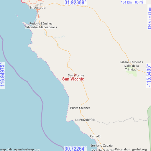
San Vicente GPS coordinates[2]
31° 19' 30.648" North, 116° 14' 47.832" West
| Map corner | latitude | longitude |
|---|---|---|
| Upper-left | 31.92389°, | -116.94975° |
| Center: | 31.32518°, | -116.24662° |
| Lower-right: | 30.72264°, | -115.5435° |
| Map W x H: | 133.6×133.6 km | = 83×83mi |
| max Lat: | 32.7° ⇑0.9% North |
| San Vicente: | 31.32518° |
| min Lat: | ⇓99.1% South 14.53588° |
| min Long | San Vicente | max Long |
| -117.105° | -116.24662° | -86.73105° |
| W 0.4%⇐ | ⇒99.6% E |
Elevation
Elevation of San Vicente is 109 m = 358 ft, and this is 1144.7 m = 3756 ft below average elevation for this country.
| Max E: |
3497 m = 11473 ft | 79.1% |
| Avg. | 1253.7 m = 4113 ft | |
| San Vicente | 109 m = 358 ft | |
Min E: |
-1 m = -3 ft | 20.9% |
See also: Mexico elevation on elevation.city.
Geographical zone
San Vicente is located in North temperate zone (between Tropic of Cancer and the Arctic Circle). Distance of this Northern Tropic circle is 877.1 km =545 mi to South.| Distance of | km | miles | from San Vicente |
|---|---|---|---|
| North Pole | 6524 | 4053.8 | to North |
| Arctic Circle | 3918.1 | 2434.6 | to North |
| Tropic Cancer | 877.1 | 545 | to South |
| Equator | 3483 | 2164.2 | to South |


Nearby cities:
15 places around San Vicente: (largest is in red/bold)
• Benito García (El Zorrillo)
45.9 km =28.5 mi,  326°
326°
• Camalú
56.5 km =35.1 mi,  161°
161°
• Colonia Esperanza (Cañón San Carlos)
55.9 km =34.7 mi, 329°
• Colonia Gómez Morín
68 km =42.3 mi,  335°
335°
• Colonia Militar Elpidio Berlanga de León
62.1 km =38.6 mi, 160°
• Emiliano Zapata
67.6 km =42 mi, 159°
• Fraccionamiento del Valle
65.2 km =40.5 mi,  358°
358°
• Héroes de la Independencia
46.3 km =28.8 mi,  46°
46°
• La Providencia
40.5 km =25.2 mi,  168°
168°
• Las Brisas
41.3 km =25.7 mi, 169°
• Licenciado Gustavo Díaz Ordaz
39.9 km =24.8 mi, 167°
• Poblado Chulavista (El Chorizo)
68.3 km =42.4 mi, 160°
• Rodolfo Sánchez Taboada
53.7 km =33.4 mi,  324°
324°
• Santa Candelaria
57.8 km =35.9 mi, 162°
• Uruapan
37.8 km =23.5 mi, 331°
Sources, notices
• [Note1] Compared only with cities in Mexico existing in our database
• [Src1] Map data: © OpenStreetMap contributors (CC-BY-SA)
• [Src2] Other city data from geonames.org with taken over terms of usage.
• [Src3] Geographical zone / Annual Mean Temperature by Robert A. Rohde @ Wikipedia
