Zacatecas geodata
Zacatecas (Nuevo León) is a populated place; located in Mexico in America/Monterrey (GMT-6) time zone. With population of 857 people, there are 10207 cities with bigger population in this country. Compared to other cities in Mexico, 94.3% of cities are located further ↓South; 65.3% of cities are located further →East and 70.9% of cities have higher elevation than Zacatecas. Note1


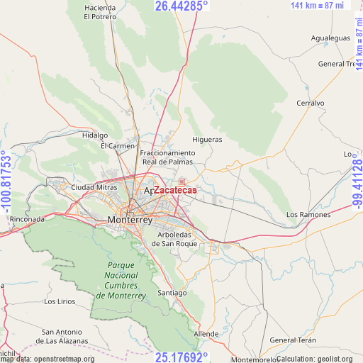
Zacatecas GPS coordinates[2]
25° 48' 41.688" North, 100° 6' 51.84" West
| Map corner | latitude | longitude |
|---|---|---|
| Upper-left | 26.44285°, | -100.81753° |
| Center: | 25.81158°, | -100.1144° |
| Lower-right: | 25.17692°, | -99.41128° |
| Map W x H: | 140.8×140.8 km | = 87.5×87.5mi |
| max Lat: | 32.7° ⇑5.7% North |
| Zacatecas: | 25.81158° |
| min Lat: | ⇓94.3% South 14.53588° |
| min Long | Zacatecas | max Long |
| -117.105° | -100.1144° | -86.73105° |
| W 34.7%⇐ | ⇒65.3% E |
Elevation
Elevation of Zacatecas is 373 m = 1224 ft, and this is 880.7 m = 2889 ft below average elevation for this country.
| Max E: |
3497 m = 11473 ft | 70.9% |
| Avg. | 1253.7 m = 4113 ft | |
| Zacatecas | 373 m = 1224 ft | |
Min E: |
-1 m = -3 ft | 29.1% |
See also: Mexico elevation on elevation.city.
Geographical zone
Zacatecas is located in North temperate zone (between Tropic of Cancer and the Arctic Circle). Distance of this Northern Tropic circle is 264.1 km =164.1 mi to South.| Distance of | km | miles | from Zacatecas |
|---|---|---|---|
| North Pole | 7137.1 | 4434.8 | to North |
| Arctic Circle | 4531.2 | 2815.6 | to North |
| Tropic Cancer | 264.1 | 164.1 | to South |
| Equator | 2870 | 1783.3 | to South |


Nearby cities:
15 places around Zacatecas: (largest is in red/bold)
• Agua Fría
3.3 km =2.1 mi,  271°
271°
• Artemio Treviño
3.9 km =2.4 mi,  312°
312°
• Ciudad Apodaca
8.1 km =5 mi,  246°
246°
• Colinas del Aeropuerto
1.3 km =0.8 mi,  62°
62°
• Dulces Nombres
9.7 km =6 mi,  161°
161°
• Fraccionamiento Misión de San Javier
8.2 km =5.1 mi,  207°
207°
• Fraccionamiento Real Palmas
11.2 km =7 mi,  336°
336°
• General Zuazua
9.3 km =5.8 mi,  3°
3°
• Ladrillera (Entronque Pesquería)
1.6 km =1 mi,  125°
125°
• Lomas de San Martín
7.2 km =4.5 mi,  184°
184°
• Los Olmos
9.1 km =5.7 mi,  196°
196°
• Misión San Pablo
8.5 km =5.3 mi, 200°
• Paseo de San Javier
8.2 km =5.1 mi,  194°
194°
• Pesquería
7 km =4.3 mi,  114°
114°
• Santa Rosa
10.8 km =6.7 mi,  277°
277°
Sources, notices
• [Note1] Compared only with cities in Mexico existing in our database
• [Src1] Map data: © OpenStreetMap contributors (CC-BY-SA)
• [Src2] Other city data from geonames.org with taken over terms of usage.
• [Src3] Geographical zone / Annual Mean Temperature by Robert A. Rohde @ Wikipedia
