Paseo de San Javier geodata
Paseo de San Javier (Nuevo León) is a populated place; located in Mexico in America/Monterrey (GMT-6) time zone. With population of 1,516 people, there are 5688 cities with bigger population in this country. Compared to other cities in Mexico, 93.9% of cities are located further ↓South; 65.6% of cities are located further →East and 70.5% of cities have higher elevation than Paseo de San Javier. Note1


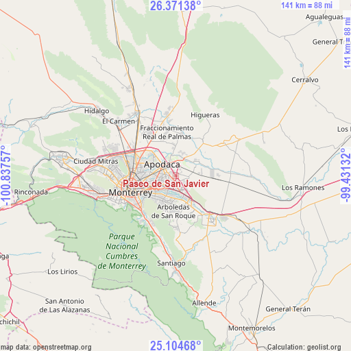
Paseo de San Javier GPS coordinates[2]
25° 44' 22.992" North, 100° 8' 3.984" West
| Map corner | latitude | longitude |
|---|---|---|
| Upper-left | 26.37138°, | -100.83757° |
| Center: | 25.73972°, | -100.13444° |
| Lower-right: | 25.10468°, | -99.43132° |
| Map W x H: | 140.8×140.8 km | = 87.5×87.5mi |
| max Lat: | 32.7° ⇑6.1% North |
| Paseo de San Javier: | 25.73972° |
| min Lat: | ⇓93.9% South 14.53588° |
| min Long | Paseo de San Ja | max Long |
| -117.105° | -100.13444° | -86.73105° |
| W 34.4%⇐ | ⇒65.6% E |
Elevation
Elevation of Paseo de San Javier is 394 m = 1293 ft, and this is 859.7 m = 2821 ft below average elevation for this country.
| Max E: |
3497 m = 11473 ft | 70.5% |
| Avg. | 1253.7 m = 4113 ft | |
| Paseo de San Javier | 394 m = 1293 ft | |
Min E: |
-1 m = -3 ft | 29.5% |
See also: Mexico elevation on elevation.city.
Geographical zone
Paseo de San Javier is located in North temperate zone (between Tropic of Cancer and the Arctic Circle). Distance of this Northern Tropic circle is 256.1 km =159.1 mi to South.| Distance of | km | miles | from Paseo de San Javier |
|---|---|---|---|
| North Pole | 7145.1 | 4439.8 | to North |
| Arctic Circle | 4539.2 | 2820.5 | to North |
| Tropic Cancer | 256.1 | 159.1 | to South |
| Equator | 2862 | 1778.4 | to South |


Nearby cities:
15 places around Paseo de San Javier: (largest is in red/bold)
• Agua Fría
8.1 km =5 mi,  351°
351°
• Artemio Treviño
10.7 km =6.6 mi,  355°
355°
• Ciudad Apodaca
7.2 km =4.5 mi,  310°
310°
• Ciudad Benito Juárez
11 km =6.8 mi,  159°
159°
• Colinas del Aeropuerto
9.2 km =5.7 mi,  20°
20°
• Dulces Nombres
5.2 km =3.2 mi,  103°
103°
• Fraccionamiento Misión de San Javier
1.9 km =1.2 mi,  290°
290°
• Ladrillera (Entronque Pesquería)
7.8 km =4.8 mi,  25°
25°
• Loma la Paz
3.2 km =2 mi,  180°
180°
• Lomas de San Martín
1.7 km =1.1 mi,  60°
60°
• Los Olmos
0.9 km =0.6 mi,  216°
216°
• Misión San Pablo
1 km =0.6 mi,  271°
271°
• Pesquería
9.8 km =6.1 mi, 58°
• Prados de Santa Rosa
11.3 km =7 mi, 305°
• Zacatecas
8.2 km =5.1 mi,  14°
14°
Sources, notices
• [Note1] Compared only with cities in Mexico existing in our database
• [Src1] Map data: © OpenStreetMap contributors (CC-BY-SA)
• [Src2] Other city data from geonames.org with taken over terms of usage.
• [Src3] Geographical zone / Annual Mean Temperature by Robert A. Rohde @ Wikipedia
