Venecia geodata
Venecia (Durango) is a populated place; located in Mexico in America/Monterrey (GMT-6) time zone. With population of 1,861 people, there are 4666 cities with bigger population in this country. Compared to other cities in Mexico, 94.1% of cities are located further ↓South; 87.5% of cities are located further →East and 57.6% of cities have higher elevation than Venecia. Note1


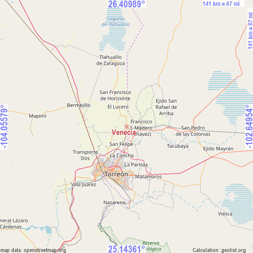
Venecia GPS coordinates[2]
25° 46' 42.384" North, 103° 21' 9.576" West
| Map corner | latitude | longitude |
|---|---|---|
| Upper-left | 26.40989°, | -104.05579° |
| Center: | 25.77844°, | -103.35266° |
| Lower-right: | 25.14361°, | -102.64954° |
| Map W x H: | 140.8×140.8 km | = 87.5×87.5mi |
| max Lat: | 32.7° ⇑5.9% North |
| Venecia: | 25.77844° |
| min Lat: | ⇓94.1% South 14.53588° |
| min Long | Venecia | max Long |
| -117.105° | -103.35266° | -86.73105° |
| W 12.5%⇐ | ⇒87.5% E |
Elevation
Elevation of Venecia is 1111 m = 3645 ft, and this is 142.7 m = 468 ft below average elevation for this country.
| Max E: |
3497 m = 11473 ft | 57.6% |
| Avg. | 1253.7 m = 4113 ft | |
| Venecia | 1111 m = 3645 ft | |
Min E: |
-1 m = -3 ft | 42.4% |
See also: Mexico elevation on elevation.city.
Geographical zone
Venecia is located in North temperate zone (between Tropic of Cancer and the Arctic Circle). Distance of this Northern Tropic circle is 260.4 km =161.8 mi to South.| Distance of | km | miles | from Venecia |
|---|---|---|---|
| North Pole | 7140.8 | 4437.1 | to North |
| Arctic Circle | 4534.9 | 2817.9 | to North |
| Tropic Cancer | 260.4 | 161.8 | to South |
| Equator | 2866.3 | 1781 | to South |


Nearby cities:
15 places around Venecia: (largest is in red/bold)
• Arcinas
5.7 km =3.5 mi,  266°
266°
• Arturo Martínez Adame
6.6 km =4.1 mi,  332°
332°
• California
3 km =1.9 mi,  229°
229°
• Compuertas
6.1 km =3.8 mi,  124°
124°
• El Pilar
6.7 km =4.2 mi,  178°
178°
• El Porvenir (El Porvenir de Arriba)
2.8 km =1.7 mi,  99°
99°
• Eureka de Media Luna (Eureka)
3.1 km =1.9 mi,  317°
317°
• Glorieta
2.8 km =1.7 mi,  359°
359°
• Jiménez
5.8 km =3.6 mi, 355°
• La Florida
3.1 km =1.9 mi,  111°
111°
• San Alberto
5.4 km =3.4 mi,  8°
8°
• San Esteban de Egipto
4.7 km =2.9 mi,  155°
155°
• Santa Cruz Luján
6 km =3.7 mi,  185°
185°
• Valle de Eureka
6.2 km =3.9 mi,  314°
314°
• Villa Gregorio García
2.9 km =1.8 mi, 178°
Sources, notices
• [Note1] Compared only with cities in Mexico existing in our database
• [Src1] Map data: © OpenStreetMap contributors (CC-BY-SA)
• [Src2] Other city data from geonames.org with taken over terms of usage.
• [Src3] Geographical zone / Annual Mean Temperature by Robert A. Rohde @ Wikipedia
