Jiménez geodata
Jiménez (Durango) is a populated place; located in Mexico in America/Monterrey (GMT-6) time zone. With population of 1,568 people, there are 5504 cities with bigger population in this country. Compared to other cities in Mexico, 94.5% of cities are located further ↓South; 87.5% of cities are located further →East and 57.9% of cities have higher elevation than Jiménez. Note1


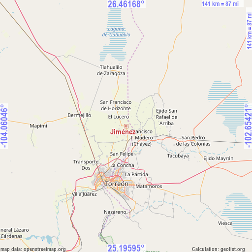
Jiménez GPS coordinates[2]
25° 49' 49.836" North, 103° 21' 26.388" West
| Map corner | latitude | longitude |
|---|---|---|
| Upper-left | 26.46168°, | -104.06046° |
| Center: | 25.83051°, | -103.35733° |
| Lower-right: | 25.19595°, | -102.65421° |
| Map W x H: | 140.7×140.7 km | = 87.4×87.4mi |
| max Lat: | 32.7° ⇑5.5% North |
| Jiménez: | 25.83051° |
| min Lat: | ⇓94.5% South 14.53588° |
| min Long | Jiménez | max Long |
| -117.105° | -103.35733° | -86.73105° |
| W 12.5%⇐ | ⇒87.5% E |
Elevation
Elevation of Jiménez is 1106 m = 3629 ft, and this is 147.7 m = 485 ft below average elevation for this country.
| Max E: |
3497 m = 11473 ft | 57.9% |
| Avg. | 1253.7 m = 4113 ft | |
| Jiménez | 1106 m = 3629 ft | |
Min E: |
-1 m = -3 ft | 42.1% |
See also: Mexico elevation on elevation.city.
Geographical zone
Jiménez is located in North temperate zone (between Tropic of Cancer and the Arctic Circle). Distance of this Northern Tropic circle is 266.2 km =165.4 mi to South.| Distance of | km | miles | from Jiménez |
|---|---|---|---|
| North Pole | 7135 | 4433.5 | to North |
| Arctic Circle | 4529.1 | 2814.3 | to North |
| Tropic Cancer | 266.2 | 165.4 | to South |
| Equator | 2872.1 | 1784.6 | to South |


Nearby cities:
15 places around Jiménez: (largest is in red/bold)
• Arturo Martínez Adame
2.6 km =1.6 mi,  272°
272°
• Banco Nacional
4.5 km =2.8 mi,  0°
0°
• El Barro
3.7 km =2.3 mi,  276°
276°
• El Lucero
6.9 km =4.3 mi,  319°
319°
• El Porvenir (El Porvenir de Arriba)
7 km =4.3 mi,  152°
152°
• Eureka de Media Luna (Eureka)
3.9 km =2.4 mi,  204°
204°
• Florencia
4.8 km =3 mi,  79°
79°
• Glorieta
3 km =1.9 mi,  171°
171°
• Hidalgo
7.6 km =4.7 mi,  101°
101°
• Huitrón
3.1 km =1.9 mi,  16°
16°
• La Florida
7.7 km =4.8 mi, 154°
• Las Mercedes
6.1 km =3.8 mi, 80°
• San Alberto
1.3 km =0.8 mi,  108°
108°
• Valle de Eureka
4.2 km =2.6 mi,  250°
250°
• Venecia
5.8 km =3.6 mi,  175°
175°
Sources, notices
• [Note1] Compared only with cities in Mexico existing in our database
• [Src1] Map data: © OpenStreetMap contributors (CC-BY-SA)
• [Src2] Other city data from geonames.org with taken over terms of usage.
• [Src3] Geographical zone / Annual Mean Temperature by Robert A. Rohde @ Wikipedia
