Tejocote de Calera geodata
Tejocote de Calera (Guanajuato) is a populated place; located in Mexico in America/Mexico_City (GMT-6) time zone. With population of 1,510 people, there are 5715 cities with bigger population in this country. Compared to other cities in Mexico, 60.9% of cities are located further ↓South; 76.4% of cities are located further →East and 72.8% of cities have lower elevation than Tejocote de Calera. Note1


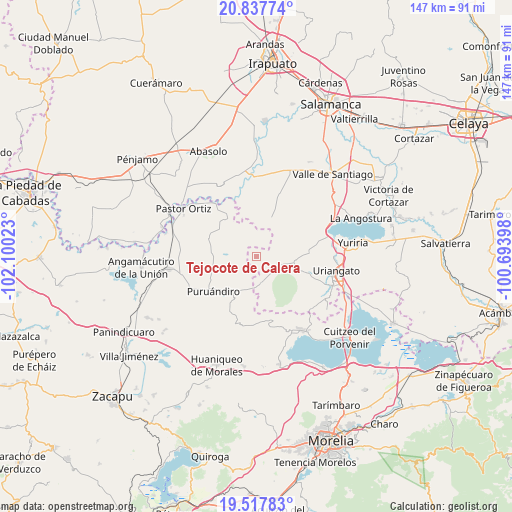
Tejocote de Calera GPS coordinates[2]
20° 10' 45.048" North, 101° 23' 49.56" West
| Map corner | latitude | longitude |
|---|---|---|
| Upper-left | 20.83774°, | -102.10023° |
| Center: | 20.17918°, | -101.3971° |
| Lower-right: | 19.51783°, | -100.69398° |
| Map W x H: | 146.8×146.8 km | = 91.2×91.2mi |
| max Lat: | 32.7° ⇑39.1% North |
| Tejocote de Calera: | 20.17918° |
| min Lat: | ⇓60.9% South 14.53588° |
| min Long | Tejocote de Cal | max Long |
| -117.105° | -101.3971° | -86.73105° |
| W 23.6%⇐ | ⇒76.4% E |
Elevation
Elevation of Tejocote de Calera is 1985 m = 6512 ft, and this is 731.3 m = 2399 ft above average elevation for this country.
| Max E: |
3497 m = 11473 ft | 27.2% |
| Tejocote de Calera | 1985 m 6512 ft | |
| Avg. | 1253.7 m = 4113 ft | |
Min E: |
-1 m = -3 ft | 72.8% |
See also: Mexico elevation on elevation.city.
Geographical zone
Tejocote de Calera is located in North Torrid zone (between Equator and Tropic of Cancer). Distance of this Northern Tropic circle is 362.2 km =225.1 mi to North.| Distance of | km | miles | from Tejocote de Calera |
|---|---|---|---|
| North Pole | 7763.3 | 4823.9 | to North |
| Arctic Circle | 5157.5 | 3204.7 | to North |
| Tropic Cancer | 362.2 | 225.1 | to North |
| Equator | 2243.7 | 1394.2 | to South |


Nearby cities:
15 places around Tejocote de Calera: (largest is in red/bold)
• Cerano
7.9 km =4.9 mi,  172°
172°
• Chamacuero
3.4 km =2.1 mi,  352°
352°
• El Canario
6.9 km =4.3 mi,  111°
111°
• El Pilar
7 km =4.3 mi,  355°
355°
• Huatajo
8 km =5 mi,  269°
269°
• La Calera
6.6 km =4.1 mi, 111°
• Laguna Prieta
6.7 km =4.2 mi,  50°
50°
• Las Letras
6.9 km =4.3 mi,  326°
326°
• Las Ranas
9.1 km =5.7 mi,  291°
291°
• Las Tortugas (Emiliano Zapata)
4.7 km =2.9 mi,  201°
201°
• Los Reyes
4.9 km =3 mi, 330°
• Ojos de Agua de Cerano
8.4 km =5.2 mi,  158°
158°
• Providencia de Calera
0.9 km =0.6 mi, 54°
• San Andrés Calera
2.6 km =1.6 mi,  145°
145°
• Santa Clara
3.8 km =2.4 mi, 269°
Sources, notices
• [Note1] Compared only with cities in Mexico existing in our database
• [Src1] Map data: © OpenStreetMap contributors (CC-BY-SA)
• [Src2] Other city data from geonames.org with taken over terms of usage.
• [Src3] Geographical zone / Annual Mean Temperature by Robert A. Rohde @ Wikipedia
