Los Reyes geodata
Los Reyes (Michoacán) is a populated place; located in Mexico in America/Mexico_City (GMT-6) time zone. With population of 786 people, there are 11112 cities with bigger population in this country. Compared to other cities in Mexico, 61.8% of cities are located further ↓South; 76.7% of cities are located further →East and 74.2% of cities have lower elevation than Los Reyes. Note1


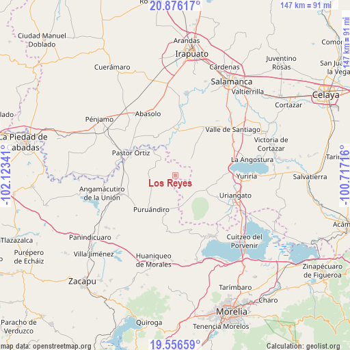
Los Reyes GPS coordinates[2]
20° 13' 4.008" North, 101° 25' 13.008" West
| Map corner | latitude | longitude |
|---|---|---|
| Upper-left | 20.87617°, | -102.12341° |
| Center: | 20.21778°, | -101.42028° |
| Lower-right: | 19.55659°, | -100.71716° |
| Map W x H: | 146.7×146.7 km | = 91.2×91.2mi |
| max Lat: | 32.7° ⇑38.2% North |
| Los Reyes: | 20.21778° |
| min Lat: | ⇓61.8% South 14.53588° |
| min Long | Los Reyes | max Long |
| -117.105° | -101.42028° | -86.73105° |
| W 23.3%⇐ | ⇒76.7% E |
Elevation
Elevation of Los Reyes is 2017 m = 6617 ft, and this is 763.3 m = 2504 ft above average elevation for this country.
| Max E: |
3497 m = 11473 ft | 25.8% |
| Los Reyes | 2017 m 6617 ft | |
| Avg. | 1253.7 m = 4113 ft | |
Min E: |
-1 m = -3 ft | 74.2% |
See also: Mexico elevation on elevation.city.
Geographical zone
Los Reyes is located in North Torrid zone (between Equator and Tropic of Cancer). Distance of this Northern Tropic circle is 357.9 km =222.4 mi to North.| Distance of | km | miles | from Los Reyes |
|---|---|---|---|
| North Pole | 7759.1 | 4821.3 | to North |
| Arctic Circle | 5153.2 | 3202 | to North |
| Tropic Cancer | 357.9 | 222.4 | to North |
| Equator | 2248 | 1396.8 | to South |


Nearby cities:
15 places around Los Reyes: (largest is in red/bold)
• Chamacuero
2.1 km =1.3 mi,  114°
114°
• El Pilar
3.3 km =2.1 mi,  35°
35°
• Huatajo
7.1 km =4.4 mi,  231°
231°
• Isaac Arriaga (Santa Ana Mancera)
8.3 km =5.2 mi,  292°
292°
• Laguna Prieta
7.6 km =4.7 mi,  90°
90°
• Las Cañas
8.7 km =5.4 mi,  1°
1°
• Las Letras
2 km =1.2 mi,  316°
316°
• Las Ranas
6.1 km =3.8 mi,  260°
260°
• Las Sanguijuelas
5.1 km =3.2 mi,  354°
354°
• Las Tortugas (Emiliano Zapata)
8.6 km =5.3 mi,  175°
175°
• Providencia de Calera
4.9 km =3 mi,  139°
139°
• San Andrés Calera
7.5 km =4.7 mi,  148°
148°
• San José Huipana
8.4 km =5.2 mi, 322°
• Santa Clara
4.5 km =2.8 mi,  197°
197°
• Tejocote de Calera
4.9 km =3 mi, 150°
Sources, notices
• [Note1] Compared only with cities in Mexico existing in our database
• [Src1] Map data: © OpenStreetMap contributors (CC-BY-SA)
• [Src2] Other city data from geonames.org with taken over terms of usage.
• [Src3] Geographical zone / Annual Mean Temperature by Robert A. Rohde @ Wikipedia
