Santa Clara geodata
Santa Clara (Guanajuato) is a populated place; located in Mexico in America/Mexico_City (GMT-6) time zone. With population of 2,633 people, there are 3358 cities with bigger population in this country. Compared to other cities in Mexico, 60.9% of cities are located further ↓South; 76.8% of cities are located further →East and 73.3% of cities have lower elevation than Santa Clara. Note1


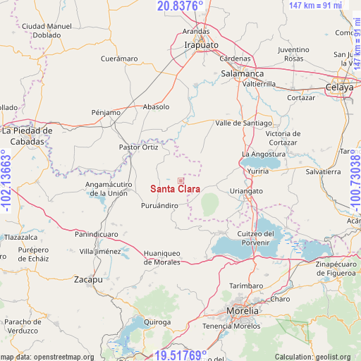
Santa Clara GPS coordinates[2]
20° 10' 44.544" North, 101° 26' 0.6" West
| Map corner | latitude | longitude |
|---|---|---|
| Upper-left | 20.8376°, | -102.13663° |
| Center: | 20.17904°, | -101.4335° |
| Lower-right: | 19.51769°, | -100.73038° |
| Map W x H: | 146.8×146.8 km | = 91.2×91.2mi |
| max Lat: | 32.7° ⇑39.1% North |
| Santa Clara: | 20.17904° |
| min Lat: | ⇓60.9% South 14.53588° |
| min Long | Santa Clara | max Long |
| -117.105° | -101.4335° | -86.73105° |
| W 23.2%⇐ | ⇒76.8% E |
Elevation
Elevation of Santa Clara is 1998 m = 6555 ft, and this is 744.3 m = 2442 ft above average elevation for this country.
| Max E: |
3497 m = 11473 ft | 26.7% |
| Santa Clara | 1998 m 6555 ft | |
| Avg. | 1253.7 m = 4113 ft | |
Min E: |
-1 m = -3 ft | 73.3% |
See also: Mexico elevation on elevation.city.
Geographical zone
Santa Clara is located in North Torrid zone (between Equator and Tropic of Cancer). Distance of this Northern Tropic circle is 362.2 km =225.1 mi to North.| Distance of | km | miles | from Santa Clara |
|---|---|---|---|
| North Pole | 7763.4 | 4824 | to North |
| Arctic Circle | 5157.5 | 3204.7 | to North |
| Tropic Cancer | 362.2 | 225.1 | to North |
| Equator | 2243.7 | 1394.2 | to South |


Nearby cities:
15 places around Santa Clara: (largest is in red/bold)
• Cerano
9.2 km =5.7 mi,  148°
148°
• Chamacuero
4.8 km =3 mi,  44°
44°
• El Pilar
7.7 km =4.8 mi,  25°
25°
• Huatajo
4.2 km =2.6 mi,  268°
268°
• La Excusa
7.4 km =4.6 mi,  237°
237°
• Las Letras
5.8 km =3.6 mi,  359°
359°
• Las Ranas
5.7 km =3.5 mi,  305°
305°
• Las Sanguijuelas
9.5 km =5.9 mi,  5°
5°
• Las Tortugas (Emiliano Zapata)
4.8 km =3 mi, 154°
• Los Reyes
4.5 km =2.8 mi,  17°
17°
• Providencia de Calera
4.6 km =2.9 mi,  82°
82°
• San Andrés Calera
5.7 km =3.5 mi,  111°
111°
• San José del Reparo
9.6 km =6 mi,  289°
289°
• San Nicolás
8.8 km =5.5 mi, 269°
• Tejocote de Calera
3.8 km =2.4 mi,  89°
89°
Sources, notices
• [Note1] Compared only with cities in Mexico existing in our database
• [Src1] Map data: © OpenStreetMap contributors (CC-BY-SA)
• [Src2] Other city data from geonames.org with taken over terms of usage.
• [Src3] Geographical zone / Annual Mean Temperature by Robert A. Rohde @ Wikipedia
