Tamazula geodata
Tamazula (Sinaloa) is a populated place; located in Mexico in America/Mazatlan (GMT-7) time zone. With population of 3,217 people, there are 2814 cities with bigger population in this country. Compared to other cities in Mexico, 92.5% of cities are located further ↓South; 96.3% of cities are located further →East and 96.3% of cities have higher elevation than Tamazula. Note1


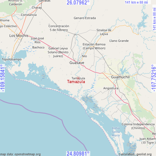
Tamazula GPS coordinates[2]
25° 26' 47.004" North, 108° 27' 19.008" West
| Map corner | latitude | longitude |
|---|---|---|
| Upper-left | 26.07962°, | -109.15841° |
| Center: | 25.44639°, | -108.45528° |
| Lower-right: | 24.80981°, | -107.75216° |
| Map W x H: | 141.2×141.2 km | = 87.7×87.7mi |
| max Lat: | 32.7° ⇑7.5% North |
| Tamazula: | 25.44639° |
| min Lat: | ⇓92.5% South 14.53588° |
| min Long | Tamazula | max Long |
| -117.105° | -108.45528° | -86.73105° |
| W 3.7%⇐ | ⇒96.3% E |
Elevation
Elevation of Tamazula is 11 m = 36 ft, and this is 1242.7 m = 4077 ft below average elevation for this country.
| Max E: |
3497 m = 11473 ft | 96.3% |
| Avg. | 1253.7 m = 4113 ft | |
| Tamazula | 11 m = 36 ft | |
Min E: |
-1 m = -3 ft | 3.7% |
See also: Mexico elevation on elevation.city.
Geographical zone
Tamazula is located in North temperate zone (between Tropic of Cancer and the Arctic Circle). Distance of this Northern Tropic circle is 223.5 km =138.9 mi to South.| Distance of | km | miles | from Tamazula |
|---|---|---|---|
| North Pole | 7177.7 | 4460 | to North |
| Arctic Circle | 4571.8 | 2840.8 | to North |
| Tropic Cancer | 223.5 | 138.9 | to South |
| Equator | 2829.4 | 1758.1 | to South |


Nearby cities:
15 places around Tamazula: (largest is in red/bold)
• Bebelama
4.8 km =3 mi,  314°
314°
• Buen Retiro (El Retiro)
2.9 km =1.8 mi, 306°
• Casa Blanca
3.7 km =2.3 mi,  118°
118°
• Chorohui
7.8 km =4.8 mi,  355°
355°
• Cubiri
5.7 km =3.5 mi,  160°
160°
• El Amole
6.8 km =4.2 mi,  165°
165°
• Javier Rojo Gómez
9.5 km =5.9 mi,  55°
55°
• La Brecha
9.2 km =5.7 mi, 156°
• Las Playas (La Palma)
6.5 km =4 mi,  149°
149°
• Marcol
8.1 km =5 mi, 311°
• Palos Verdes
7.5 km =4.7 mi,  182°
182°
• Pitahayal
9.2 km =5.7 mi,  72°
72°
• San Gabriel
9.5 km =5.9 mi,  347°
347°
• San Pedro Paredes
9.7 km =6 mi,  9°
9°
• Vicente Guerrero
9.4 km =5.8 mi, 65°
Sources, notices
• [Note1] Compared only with cities in Mexico existing in our database
• [Src1] Map data: © OpenStreetMap contributors (CC-BY-SA)
• [Src2] Other city data from geonames.org with taken over terms of usage.
• [Src3] Geographical zone / Annual Mean Temperature by Robert A. Rohde @ Wikipedia
