Chorohui geodata
Chorohui (Sinaloa) is a populated place; located in Mexico in America/Mazatlan (GMT-7) time zone. With population of 598 people, there are 14373 cities with bigger population in this country. Compared to other cities in Mexico, 92.8% of cities are located further ↓South; 96.3% of cities are located further →East and 92.5% of cities have higher elevation than Chorohui. Note1


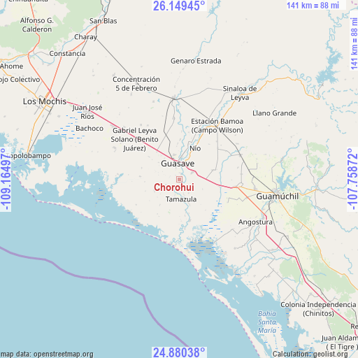
Chorohui GPS coordinates[2]
25° 30' 59.724" North, 108° 27' 42.624" West
| Map corner | latitude | longitude |
|---|---|---|
| Upper-left | 26.14945°, | -109.16497° |
| Center: | 25.51659°, | -108.46184° |
| Lower-right: | 24.88038°, | -107.75872° |
| Map W x H: | 141.1×141.1 km | = 87.7×87.7mi |
| max Lat: | 32.7° ⇑7.2% North |
| Chorohui: | 25.51659° |
| min Lat: | ⇓92.8% South 14.53588° |
| min Long | Chorohui | max Long |
| -117.105° | -108.46184° | -86.73105° |
| W 3.7%⇐ | ⇒96.3% E |
Elevation
Elevation of Chorohui is 18 m = 59 ft, and this is 1235.7 m = 4054 ft below average elevation for this country.
| Max E: |
3497 m = 11473 ft | 92.5% |
| Avg. | 1253.7 m = 4113 ft | |
| Chorohui | 18 m = 59 ft | |
Min E: |
-1 m = -3 ft | 7.5% |
See also: Mexico elevation on elevation.city.
Geographical zone
Chorohui is located in North temperate zone (between Tropic of Cancer and the Arctic Circle). Distance of this Northern Tropic circle is 231.3 km =143.7 mi to South.| Distance of | km | miles | from Chorohui |
|---|---|---|---|
| North Pole | 7169.9 | 4455.2 | to North |
| Arctic Circle | 4564 | 2835.9 | to North |
| Tropic Cancer | 231.3 | 143.7 | to South |
| Equator | 2837.2 | 1763 | to South |


Nearby cities:
15 places around Chorohui: (largest is in red/bold)
• Bebelama
5.2 km =3.2 mi,  212°
212°
• Buen Retiro (El Retiro)
6.3 km =3.9 mi,  195°
195°
• El Burrión
5.5 km =3.4 mi,  63°
63°
• Guasave
5.7 km =3.5 mi,  354°
354°
• Guasavito
4.9 km =3 mi,  33°
33°
• Javier Rojo Gómez
8.8 km =5.5 mi,  106°
106°
• La Chuparrosa
8.7 km =5.4 mi,  286°
286°
• La Sabanilla (Campo Preciado)
6.6 km =4.1 mi,  312°
312°
• Las Crucecitas
7.5 km =4.7 mi,  18°
18°
• Marcol
6 km =3.7 mi,  245°
245°
• Ranchito de Castro
9 km =5.6 mi, 29°
• San Gabriel
2 km =1.2 mi,  317°
317°
• San Pedro Guasave
2.4 km =1.5 mi,  12°
12°
• San Pedro Paredes
2.8 km =1.7 mi,  51°
51°
• Tamazula
7.8 km =4.8 mi,  175°
175°
Sources, notices
• [Note1] Compared only with cities in Mexico existing in our database
• [Src1] Map data: © OpenStreetMap contributors (CC-BY-SA)
• [Src2] Other city data from geonames.org with taken over terms of usage.
• [Src3] Geographical zone / Annual Mean Temperature by Robert A. Rohde @ Wikipedia
