Pitahayal geodata
Pitahayal (Sinaloa) is a populated place; located in Mexico in America/Mazatlan (GMT-7) time zone. With population of 1,248 people, there are 6955 cities with bigger population in this country. Compared to other cities in Mexico, 92.6% of cities are located further ↓South; 96.1% of cities are located further →East and 93.5% of cities have higher elevation than Pitahayal. Note1


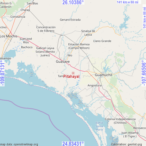
Pitahayal GPS coordinates[2]
25° 28' 14.736" North, 108° 22' 5.448" West
| Map corner | latitude | longitude |
|---|---|---|
| Upper-left | 26.10386°, | -109.07131° |
| Center: | 25.47076°, | -108.36818° |
| Lower-right: | 24.83431°, | -107.66506° |
| Map W x H: | 141.2×141.2 km | = 87.7×87.7mi |
| max Lat: | 32.7° ⇑7.4% North |
| Pitahayal: | 25.47076° |
| min Lat: | ⇓92.6% South 14.53588° |
| min Long | Pitahayal | max Long |
| -117.105° | -108.36818° | -86.73105° |
| W 3.9%⇐ | ⇒96.1% E |
Elevation
Elevation of Pitahayal is 16 m = 52 ft, and this is 1237.7 m = 4061 ft below average elevation for this country.
| Max E: |
3497 m = 11473 ft | 93.5% |
| Avg. | 1253.7 m = 4113 ft | |
| Pitahayal | 16 m = 52 ft | |
Min E: |
-1 m = -3 ft | 6.5% |
See also: Mexico elevation on elevation.city.
Geographical zone
Pitahayal is located in North temperate zone (between Tropic of Cancer and the Arctic Circle). Distance of this Northern Tropic circle is 226.2 km =140.6 mi to South.| Distance of | km | miles | from Pitahayal |
|---|---|---|---|
| North Pole | 7175 | 4458.3 | to North |
| Arctic Circle | 4569.1 | 2839.1 | to North |
| Tropic Cancer | 226.2 | 140.6 | to South |
| Equator | 2832.1 | 1759.8 | to South |


Nearby cities:
15 places around Pitahayal: (largest is in red/bold)
• Casa Blanca
7.1 km =4.4 mi,  230°
230°
• Cruz Blanca
9.7 km =6 mi,  103°
103°
• Cubiri
10.6 km =6.6 mi,  220°
220°
• El Burrión
8.8 km =5.5 mi,  329°
329°
• El Platanito
10.4 km =6.5 mi,  31°
31°
• Javier Rojo Gómez
2.8 km =1.7 mi,  340°
340°
• La Pichihuila
10 km =6.2 mi,  39°
39°
• Las Colonias (Colonia Ángel Flores)
7.1 km =4.4 mi,  171°
171°
• Las Playas (La Palma)
10 km =6.2 mi,  213°
213°
• Rodolfo Sánchez Taboada (Las Lagunitas)
10.4 km =6.5 mi,  112°
112°
• San Pedro Paredes
9.9 km =6.2 mi,  313°
313°
• San Rafael
6.8 km =4.2 mi,  67°
67°
• Tamazula
9.2 km =5.7 mi,  252°
252°
• Terahuito
10.1 km =6.3 mi, 28°
• Vicente Guerrero
1.2 km =0.7 mi,  352°
352°
Sources, notices
• [Note1] Compared only with cities in Mexico existing in our database
• [Src1] Map data: © OpenStreetMap contributors (CC-BY-SA)
• [Src2] Other city data from geonames.org with taken over terms of usage.
• [Src3] Geographical zone / Annual Mean Temperature by Robert A. Rohde @ Wikipedia
