Sayulilla geodata
Sayulilla (Nayarit) is a populated place; located in Mexico in America/Mazatlan (GMT-7) time zone. With population of 2,277 people, there are 3869 cities with bigger population in this country. Compared to other cities in Mexico, 86.5% of cities are located further ↓South; 93% of cities are located further →East and 91.2% of cities have higher elevation than Sayulilla. Note1


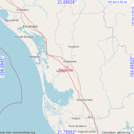
Sayulilla GPS coordinates[2]
22° 26' 17.592" North, 105° 23' 28.932" West
| Map corner | latitude | longitude |
|---|---|---|
| Upper-left | 23.08658°, | -106.0945° |
| Center: | 22.43822°, | -105.39137° |
| Lower-right: | 21.78682°, | -104.68825° |
| Map W x H: | 144.5×144.5 km | = 89.8×89.8mi |
| max Lat: | 32.7° ⇑13.5% North |
| Sayulilla: | 22.43822° |
| min Lat: | ⇓86.5% South 14.53588° |
| min Long | Sayulilla | max Long |
| -117.105° | -105.39137° | -86.73105° |
| W 7%⇐ | ⇒93% E |
Elevation
Elevation of Sayulilla is 21 m = 69 ft, and this is 1232.7 m = 4044 ft below average elevation for this country.
| Max E: |
3497 m = 11473 ft | 91.2% |
| Avg. | 1253.7 m = 4113 ft | |
| Sayulilla | 21 m = 69 ft | |
Min E: |
-1 m = -3 ft | 8.8% |
See also: Mexico elevation on elevation.city.
Geographical zone
Sayulilla is located in North Torrid zone (between Equator and Tropic of Cancer). Distance of this Northern Tropic circle is 111 km =69 mi to North.| Distance of | km | miles | from Sayulilla |
|---|---|---|---|
| North Pole | 7512.2 | 4667.9 | to North |
| Arctic Circle | 4906.3 | 3048.6 | to North |
| Tropic Cancer | 111 | 69 | to North |
| Equator | 2494.9 | 1550.3 | to South |


Nearby cities:
15 places around Sayulilla: (largest is in red/bold)
• Acaponeta
6.8 km =4.2 mi,  24°
24°
• Atotonilco
11 km =6.8 mi,  239°
239°
• Camalotita
5.6 km =3.5 mi,  227°
227°
• El Arrayán
11.9 km =7.4 mi,  189°
189°
• El Centenario
8.6 km =5.3 mi, 18°
• El Filo
9.5 km =5.9 mi, 227°
• El Recodo
10.6 km =6.6 mi,  28°
28°
• El Resbalón
10.4 km =6.5 mi,  118°
118°
• El Tigre
10.2 km =6.3 mi,  311°
311°
• La Guásima
3.6 km =2.2 mi,  173°
173°
• La Presa
10.5 km =6.5 mi,  181°
181°
• Llano de la Cruz
1.6 km =1 mi,  105°
105°
• San Felipe Aztatán
6.7 km =4.2 mi,  205°
205°
• San José de Gracia
4.9 km =3 mi, 15°
• Tecuala
8.2 km =5.1 mi, 236°
Sources, notices
• [Note1] Compared only with cities in Mexico existing in our database
• [Src1] Map data: © OpenStreetMap contributors (CC-BY-SA)
• [Src2] Other city data from geonames.org with taken over terms of usage.
• [Src3] Geographical zone / Annual Mean Temperature by Robert A. Rohde @ Wikipedia
