Santa Matilde geodata
Santa Matilde (Querétaro) is a populated place; located in Mexico in America/Mexico_City (GMT-6) time zone. With population of 1,537 people, there are 5623 cities with bigger population in this country. Compared to other cities in Mexico, 66.3% of cities are located further ↓South; 64.3% of cities are located further →East and 69% of cities have lower elevation than Santa Matilde. Note1


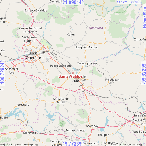
Santa Matilde GPS coordinates[2]
20° 25' 57.648" North, 100° 1' 33.996" West
| Map corner | latitude | longitude |
|---|---|---|
| Upper-left | 21.09014°, | -100.72924° |
| Center: | 20.43268°, | -100.02611° |
| Lower-right: | 19.77239°, | -99.32299° |
| Map W x H: | 146.5×146.5 km | = 91×91mi |
| max Lat: | 32.7° ⇑33.7% North |
| Santa Matilde: | 20.43268° |
| min Lat: | ⇓66.3% South 14.53588° |
| min Long | Santa Matilde | max Long |
| -117.105° | -100.02611° | -86.73105° |
| W 35.7%⇐ | ⇒64.3% E |
Elevation
Elevation of Santa Matilde is 1908 m = 6260 ft, and this is 654.3 m = 2147 ft above average elevation for this country.
| Max E: |
3497 m = 11473 ft | 31% |
| Santa Matilde | 1908 m 6260 ft | |
| Avg. | 1253.7 m = 4113 ft | |
Min E: |
-1 m = -3 ft | 69% |
See also: Mexico elevation on elevation.city.
Geographical zone
Santa Matilde is located in North Torrid zone (between Equator and Tropic of Cancer). Distance of this Northern Tropic circle is 334 km =207.5 mi to North.| Distance of | km | miles | from Santa Matilde |
|---|---|---|---|
| North Pole | 7735.2 | 4806.4 | to North |
| Arctic Circle | 5129.3 | 3187.2 | to North |
| Tropic Cancer | 334 | 207.5 | to North |
| Equator | 2271.9 | 1411.7 | to South |


Nearby cities:
15 places around Santa Matilde: (largest is in red/bold)
• Casa Blanca
5.2 km =3.2 mi,  173°
173°
• El Organal
5.8 km =3.6 mi,  329°
329°
• El Rosario
6.1 km =3.8 mi,  222°
222°
• La Estancia
4.4 km =2.7 mi,  253°
253°
• La Llave
5 km =3.1 mi,  42°
42°
• La Valla
7.4 km =4.6 mi,  359°
359°
• Laguna de Lourdes
5.7 km =3.5 mi,  335°
335°
• Loma Linda
3.6 km =2.2 mi,  188°
188°
• Pueblo Quieto
6.1 km =3.8 mi,  77°
77°
• San Germán
4.3 km =2.7 mi,  312°
312°
• San Javier
4.4 km =2.7 mi,  302°
302°
• San Juan del Río
5.8 km =3.6 mi,  147°
147°
• Santa Cruz Escandón
7.6 km =4.7 mi,  104°
104°
• Vista Hermosa (Cuasinada)
7.3 km =4.5 mi, 168°
• Visthá
5.4 km =3.4 mi,  73°
73°
Sources, notices
• [Note1] Compared only with cities in Mexico existing in our database
• [Src1] Map data: © OpenStreetMap contributors (CC-BY-SA)
• [Src2] Other city data from geonames.org with taken over terms of usage.
• [Src3] Geographical zone / Annual Mean Temperature by Robert A. Rohde @ Wikipedia
