La Estancia geodata
La Estancia (Querétaro) is a populated place; located in Mexico in America/Mexico_City (GMT-6) time zone. With population of 5,992 people, there are 1559 cities with bigger population in this country. Compared to other cities in Mexico, 66.1% of cities are located further ↓South; 64.8% of cities are located further →East and 70.6% of cities have lower elevation than La Estancia. Note1


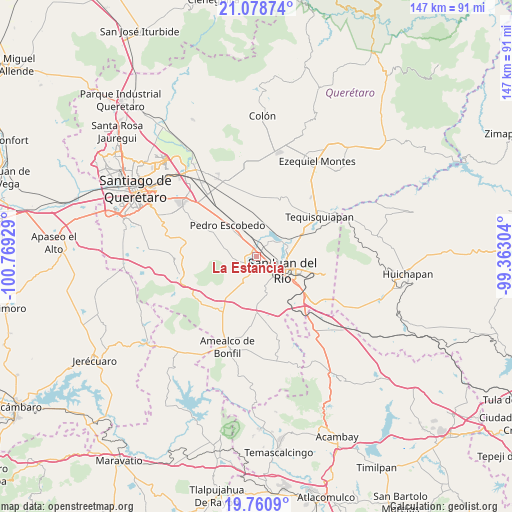
La Estancia GPS coordinates[2]
20° 25' 16.428" North, 100° 3' 58.176" West
| Map corner | latitude | longitude |
|---|---|---|
| Upper-left | 21.07874°, | -100.76929° |
| Center: | 20.42123°, | -100.06616° |
| Lower-right: | 19.7609°, | -99.36304° |
| Map W x H: | 146.5×146.5 km | = 91×91mi |
| max Lat: | 32.7° ⇑33.9% North |
| La Estancia: | 20.42123° |
| min Lat: | ⇓66.1% South 14.53588° |
| min Long | La Estancia | max Long |
| -117.105° | -100.06616° | -86.73105° |
| W 35.2%⇐ | ⇒64.8% E |
Elevation
Elevation of La Estancia is 1938 m = 6358 ft, and this is 684.3 m = 2245 ft above average elevation for this country.
| Max E: |
3497 m = 11473 ft | 29.4% |
| La Estancia | 1938 m 6358 ft | |
| Avg. | 1253.7 m = 4113 ft | |
Min E: |
-1 m = -3 ft | 70.6% |
See also: Mexico elevation on elevation.city.
Geographical zone
La Estancia is located in North Torrid zone (between Equator and Tropic of Cancer). Distance of this Northern Tropic circle is 335.3 km =208.3 mi to North.| Distance of | km | miles | from La Estancia |
|---|---|---|---|
| North Pole | 7736.4 | 4807.2 | to North |
| Arctic Circle | 5130.5 | 3187.9 | to North |
| Tropic Cancer | 335.3 | 208.3 | to North |
| Equator | 2270.6 | 1410.9 | to South |


Nearby cities:
15 places around La Estancia: (largest is in red/bold)
• Arcila
4.7 km =2.9 mi,  255°
255°
• Casa Blanca
6.2 km =3.9 mi,  128°
128°
• Dolores Cuadrilla de Enmedio
7.8 km =4.8 mi,  190°
190°
• El Coto
7.7 km =4.8 mi,  247°
247°
• El Organal
6.4 km =4 mi,  10°
10°
• El Rosario
3.3 km =2.1 mi,  179°
179°
• El Saúz
8.1 km =5 mi,  320°
320°
• Galindo
4.3 km =2.7 mi,  231°
231°
• Laguna de Lourdes
6.7 km =4.2 mi,  15°
15°
• Loma Linda
4.3 km =2.7 mi,  122°
122°
• San Germán
4.3 km =2.7 mi, 13°
• San Javier
3.7 km =2.3 mi, 6°
• San Juan del Río
8.2 km =5.1 mi, 116°
• Santa Matilde
4.4 km =2.7 mi,  73°
73°
• Vista Hermosa (Cuasinada)
8.1 km =5 mi,  136°
136°
Sources, notices
• [Note1] Compared only with cities in Mexico existing in our database
• [Src1] Map data: © OpenStreetMap contributors (CC-BY-SA)
• [Src2] Other city data from geonames.org with taken over terms of usage.
• [Src3] Geographical zone / Annual Mean Temperature by Robert A. Rohde @ Wikipedia
