San Pedro geodata
San Pedro (Coahuila) is a seat of a second-order administrative division; located in Mexico in America/Monterrey (GMT-6) time zone. With population of 48,746 people, there are 231 cities with bigger population in this country. Compared to other cities in Mexico, 94% of cities are located further ↓South; 85.7% of cities are located further →East and 58.1% of cities have higher elevation than San Pedro. Note1


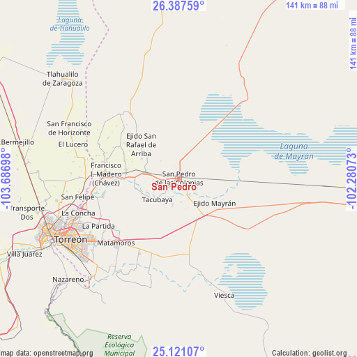
San Pedro GPS coordinates[2]
25° 45' 21.672" North, 102° 59' 1.86" West
| Map corner | latitude | longitude |
|---|---|---|
| Upper-left | 26.38759°, | -103.68698° |
| Center: | 25.75602°, | -102.98385° |
| Lower-right: | 25.12107°, | -102.28073° |
| Map W x H: | 140.8×140.8 km | = 87.5×87.5mi |
| max Lat: | 32.7° ⇑6% North |
| San Pedro: | 25.75602° |
| min Lat: | ⇓94% South 14.53588° |
| min Long | San Pedro | max Long |
| -117.105° | -102.98385° | -86.73105° |
| W 14.3%⇐ | ⇒85.7% E |
Elevation
Elevation of San Pedro is 1101 m = 3612 ft, and this is 152.7 m = 501 ft below average elevation for this country.
| Max E: |
3497 m = 11473 ft | 58.1% |
| Avg. | 1253.7 m = 4113 ft | |
| San Pedro | 1101 m = 3612 ft | |
Min E: |
-1 m = -3 ft | 41.9% |
See also: San Pedro elevation on elevation.city.
Geographical zone
San Pedro is located in North temperate zone (between Tropic of Cancer and the Arctic Circle). Distance of this Northern Tropic circle is 257.9 km =160.3 mi to South.| Distance of | km | miles | from San Pedro |
|---|---|---|---|
| North Pole | 7143.3 | 4438.6 | to North |
| Arctic Circle | 4537.4 | 2819.4 | to North |
| Tropic Cancer | 257.9 | 160.3 | to South |
| Equator | 2863.8 | 1779.5 | to South |


Nearby cities:
15 places around San Pedro: (largest is in red/bold)
• Bolívar
3.6 km =2.2 mi,  306°
306°
• Concordia
13.6 km =8.5 mi,  281°
281°
• El Estribo
15.1 km =9.4 mi, 308°
• El Nilo
4.8 km =3 mi,  121°
121°
• El Retiro
16.7 km =10.4 mi,  298°
298°
• Ignacio Zaragoza
6.1 km =3.8 mi,  171°
171°
• San Esteban de Abajo
5.5 km =3.4 mi,  197°
197°
• San Felipe
9 km =5.6 mi, 174°
• San Ignacio
10.9 km =6.8 mi,  258°
258°
• San Marcos
10.3 km =6.4 mi,  194°
194°
• San Miguel
7.1 km =4.4 mi,  152°
152°
• San Pablo
9.6 km =6 mi,  251°
251°
• San Rafael de Abajo
11 km =6.8 mi, 193°
• Santa Elena
8.5 km =5.3 mi,  212°
212°
• Tacubaya
11.7 km =7.3 mi,  226°
226°
Sources, notices
• [Note1] Compared only with cities in Mexico existing in our database
• [Src1] Map data: © OpenStreetMap contributors (CC-BY-SA)
• [Src2] Other city data from geonames.org with taken over terms of usage.
• [Src3] Geographical zone / Annual Mean Temperature by Robert A. Rohde @ Wikipedia
