El Estribo geodata
El Estribo (Coahuila) is a populated place; located in Mexico in America/Monterrey (GMT-6) time zone. With population of 967 people, there are 9002 cities with bigger population in this country. Compared to other cities in Mexico, 94.5% of cities are located further ↓South; 86.1% of cities are located further →East and 58.1% of cities have higher elevation than El Estribo. Note1


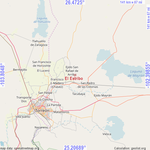
El Estribo GPS coordinates[2]
25° 50' 29.004" North, 103° 6' 6.012" West
| Map corner | latitude | longitude |
|---|---|---|
| Upper-left | 26.4725°, | -103.8048° |
| Center: | 25.84139°, | -103.10167° |
| Lower-right: | 25.20689°, | -102.39855° |
| Map W x H: | 140.7×140.7 km | = 87.4×87.4mi |
| max Lat: | 32.7° ⇑5.5% North |
| El Estribo: | 25.84139° |
| min Lat: | ⇓94.5% South 14.53588° |
| min Long | El Estribo | max Long |
| -117.105° | -103.10167° | -86.73105° |
| W 13.9%⇐ | ⇒86.1% E |
Elevation
Elevation of El Estribo is 1101 m = 3612 ft, and this is 152.7 m = 501 ft below average elevation for this country.
| Max E: |
3497 m = 11473 ft | 58.1% |
| Avg. | 1253.7 m = 4113 ft | |
| El Estribo | 1101 m = 3612 ft | |
Min E: |
-1 m = -3 ft | 41.9% |
See also: Mexico elevation on elevation.city.
Geographical zone
El Estribo is located in North temperate zone (between Tropic of Cancer and the Arctic Circle). Distance of this Northern Tropic circle is 267.4 km =166.2 mi to South.| Distance of | km | miles | from El Estribo |
|---|---|---|---|
| North Pole | 7133.8 | 4432.7 | to North |
| Arctic Circle | 4527.9 | 2813.5 | to North |
| Tropic Cancer | 267.4 | 166.2 | to South |
| Equator | 2873.3 | 1785.4 | to South |


Nearby cities:
15 places around El Estribo: (largest is in red/bold)
• Alejo González (Bilbao)
9.6 km =6 mi,  256°
256°
• Bolívar
11.5 km =7.1 mi,  129°
129°
• Concordia
7 km =4.3 mi,  192°
192°
• El Retiro
3.2 km =2 mi,  241°
241°
• Emiliano Zapata (Albia)
7.7 km =4.8 mi,  281°
281°
• La Fe
10 km =6.2 mi,  273°
273°
• La Victoria
7.9 km =4.9 mi,  288°
288°
• Luchanas
10.8 km =6.7 mi, 238°
• Primero de Mayo
7.2 km =4.5 mi,  248°
248°
• San Francisco de Arriba
11.5 km =7.1 mi,  208°
208°
• San Ignacio
11.7 km =7.3 mi,  174°
174°
• San José de la Niña
12.2 km =7.6 mi, 287°
• Sofía de Arriba
12.1 km =7.5 mi,  335°
335°
• Vega Larga
10.9 km =6.8 mi,  295°
295°
• Veinte de Noviembre (Santa Lucía)
7.6 km =4.7 mi,  220°
220°
Sources, notices
• [Note1] Compared only with cities in Mexico existing in our database
• [Src1] Map data: © OpenStreetMap contributors (CC-BY-SA)
• [Src2] Other city data from geonames.org with taken over terms of usage.
• [Src3] Geographical zone / Annual Mean Temperature by Robert A. Rohde @ Wikipedia
