Bolívar geodata
Bolívar (Coahuila) is a populated place; located in Mexico in America/Monterrey (GMT-6) time zone. With population of 560 people, there are 15231 cities with bigger population in this country. Compared to other cities in Mexico, 94.1% of cities are located further ↓South; 85.8% of cities are located further →East and 58.1% of cities have higher elevation than Bolívar. Note1


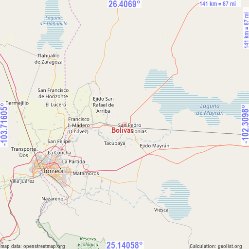
Bolívar GPS coordinates[2]
25° 46' 31.548" North, 103° 0' 46.512" West
| Map corner | latitude | longitude |
|---|---|---|
| Upper-left | 26.4069°, | -103.71605° |
| Center: | 25.77543°, | -103.01292° |
| Lower-right: | 25.14058°, | -102.3098° |
| Map W x H: | 140.8×140.8 km | = 87.5×87.5mi |
| max Lat: | 32.7° ⇑5.9% North |
| Bolívar: | 25.77543° |
| min Lat: | ⇓94.1% South 14.53588° |
| min Long | Bolívar | max Long |
| -117.105° | -103.01292° | -86.73105° |
| W 14.2%⇐ | ⇒85.8% E |
Elevation
Elevation of Bolívar is 1101 m = 3612 ft, and this is 152.7 m = 501 ft below average elevation for this country.
| Max E: |
3497 m = 11473 ft | 58.1% |
| Avg. | 1253.7 m = 4113 ft | |
| Bolívar | 1101 m = 3612 ft | |
Min E: |
-1 m = -3 ft | 41.9% |
See also: Mexico elevation on elevation.city.
Geographical zone
Bolívar is located in North temperate zone (between Tropic of Cancer and the Arctic Circle). Distance of this Northern Tropic circle is 260 km =161.6 mi to South.| Distance of | km | miles | from Bolívar |
|---|---|---|---|
| North Pole | 7141.1 | 4437.3 | to North |
| Arctic Circle | 4535.2 | 2818 | to North |
| Tropic Cancer | 260 | 161.6 | to South |
| Equator | 2866 | 1780.8 | to South |


Nearby cities:
15 places around Bolívar: (largest is in red/bold)
• Concordia
10.4 km =6.5 mi,  272°
272°
• El Estribo
11.5 km =7.1 mi,  309°
309°
• El Nilo
8.4 km =5.2 mi,  123°
123°
• El Retiro
13.1 km =8.1 mi,  296°
296°
• Ignacio Zaragoza
9 km =5.6 mi,  155°
155°
• San Esteban de Abajo
7.5 km =4.7 mi,  170°
170°
• San Felipe
11.8 km =7.3 mi, 161°
• San Ignacio
8.9 km =5.5 mi,  240°
240°
• San Marcos
12.1 km =7.5 mi,  178°
178°
• San Miguel
10.5 km =6.5 mi,  143°
143°
• San Pablo
8.1 km =5 mi,  229°
229°
• San Pedro
3.6 km =2.2 mi,  126°
126°
• San Rafael de Abajo
12.9 km =8 mi, 178°
• Santa Elena
9.5 km =5.9 mi,  190°
190°
• Tacubaya
11.6 km =7.2 mi,  208°
208°
Sources, notices
• [Note1] Compared only with cities in Mexico existing in our database
• [Src1] Map data: © OpenStreetMap contributors (CC-BY-SA)
• [Src2] Other city data from geonames.org with taken over terms of usage.
• [Src3] Geographical zone / Annual Mean Temperature by Robert A. Rohde @ Wikipedia
