San Nicolás de Ibarra geodata
San Nicolás de Ibarra (Jalisco) is a populated place; located in Mexico in America/Mexico_City (GMT-6) time zone. With population of 1,369 people, there are 6339 cities with bigger population in this country. Compared to other cities in Mexico, 64.1% of cities are located further ↓South; 86.2% of cities are located further →East and 52.6% of cities have lower elevation than San Nicolás de Ibarra. Note1


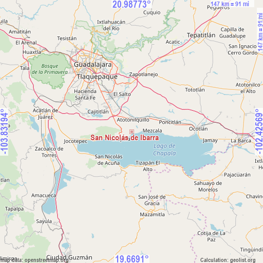
San Nicolás de Ibarra GPS coordinates[2]
20° 19' 47.352" North, 103° 7' 43.716" West
| Map corner | latitude | longitude |
|---|---|---|
| Upper-left | 20.98773°, | -103.83194° |
| Center: | 20.32982°, | -103.12881° |
| Lower-right: | 19.6691°, | -102.42569° |
| Map W x H: | 146.6×146.6 km | = 91.1×91.1mi |
| max Lat: | 32.7° ⇑35.9% North |
| San Nicolás de Ibarra: | 20.32982° |
| min Lat: | ⇓64.1% South 14.53588° |
| min Long | San Nicolás de | max Long |
| -117.105° | -103.12881° | -86.73105° |
| W 13.8%⇐ | ⇒86.2% E |
Elevation
Elevation of San Nicolás de Ibarra is 1535 m = 5036 ft, and this is 281.3 m = 923 ft above average elevation for this country.
| Max E: |
3497 m = 11473 ft | 47.4% |
| San Nicolás de Ibarra | 1535 m 5036 ft | |
| Avg. | 1253.7 m = 4113 ft | |
Min E: |
-1 m = -3 ft | 52.6% |
See also: Mexico elevation on elevation.city.
Geographical zone
San Nicolás de Ibarra is located in North Torrid zone (between Equator and Tropic of Cancer). Distance of this Northern Tropic circle is 345.5 km =214.7 mi to North.| Distance of | km | miles | from San Nicolás de Ibarra |
|---|---|---|---|
| North Pole | 7746.6 | 4813.5 | to North |
| Arctic Circle | 5140.7 | 3194.3 | to North |
| Tropic Cancer | 345.5 | 214.7 | to North |
| Equator | 2260.5 | 1404.6 | to South |


Nearby cities:
15 places around San Nicolás de Ibarra: (largest is in red/bold)
• Ajijic
13.5 km =8.4 mi,  257°
257°
• Atequiza
6.8 km =4.2 mi,  349°
349°
• Atotonilquillo
7 km =4.3 mi,  4°
4°
• Buenavista
10.8 km =6.7 mi,  303°
303°
• Chapala
7.5 km =4.7 mi,  240°
240°
• El Rodeo
10.3 km =6.4 mi,  329°
329°
• Ixtlahuacán de los Membrillos
7 km =4.3 mi,  287°
287°
• Los Cedros
12.7 km =7.9 mi, 301°
• Los Freseros (Los Sabinos)
11.8 km =7.3 mi, 331°
• Mezcala
11.6 km =7.2 mi,  86°
86°
• San Jacinto
10.7 km =6.6 mi,  44°
44°
• San Juan Tecomatlán
3 km =1.9 mi, 93°
• Santa Cruz de la Soledad
3.4 km =2.1 mi,  246°
246°
• Santa Rosa
14.6 km =9.1 mi,  310°
310°
• Valle de los Girasoles [Fraccionamiento]
13 km =8.1 mi, 325°
Sources, notices
• [Note1] Compared only with cities in Mexico existing in our database
• [Src1] Map data: © OpenStreetMap contributors (CC-BY-SA)
• [Src2] Other city data from geonames.org with taken over terms of usage.
• [Src3] Geographical zone / Annual Mean Temperature by Robert A. Rohde @ Wikipedia
