Mezcala geodata
Mezcala (Jalisco) is a populated place; located in Mexico in America/Mexico_City (GMT-6) time zone. With population of 5,005 people, there are 1845 cities with bigger population in this country. Compared to other cities in Mexico, 64.2% of cities are located further ↓South; 85.8% of cities are located further →East and 52.7% of cities have lower elevation than Mezcala. Note1


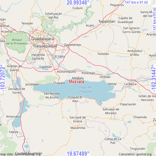
Mezcala GPS coordinates[2]
20° 20' 8.088" North, 103° 1' 3.324" West
| Map corner | latitude | longitude |
|---|---|---|
| Upper-left | 20.99346°, | -103.72072° |
| Center: | 20.33558°, | -103.01759° |
| Lower-right: | 19.67489°, | -102.31447° |
| Map W x H: | 146.6×146.6 km | = 91.1×91.1mi |
| max Lat: | 32.7° ⇑35.8% North |
| Mezcala: | 20.33558° |
| min Lat: | ⇓64.2% South 14.53588° |
| min Long | Mezcala | max Long |
| -117.105° | -103.01759° | -86.73105° |
| W 14.2%⇐ | ⇒85.8% E |
Elevation
Elevation of Mezcala is 1536 m = 5039 ft, and this is 282.3 m = 926 ft above average elevation for this country.
| Max E: |
3497 m = 11473 ft | 47.3% |
| Mezcala | 1536 m 5039 ft | |
| Avg. | 1253.7 m = 4113 ft | |
Min E: |
-1 m = -3 ft | 52.7% |
See also: Mexico elevation on elevation.city.
Geographical zone
Mezcala is located in North Torrid zone (between Equator and Tropic of Cancer). Distance of this Northern Tropic circle is 344.8 km =214.2 mi to North.| Distance of | km | miles | from Mezcala |
|---|---|---|---|
| North Pole | 7746 | 4813.1 | to North |
| Arctic Circle | 5140.1 | 3193.9 | to North |
| Tropic Cancer | 344.8 | 214.2 | to North |
| Equator | 2261.1 | 1405 | to South |


Nearby cities:
15 places around Mezcala: (largest is in red/bold)
• Atequiza
14.2 km =8.8 mi,  295°
295°
• Atotonilquillo
12.8 km =8 mi, 299°
• Chalpicote
11 km =6.8 mi,  105°
105°
• Chila
14.8 km =9.2 mi,  19°
19°
• El Romereño (INFONAVIT)
8.7 km =5.4 mi,  54°
54°
• La Colonia
13.6 km =8.5 mi,  41°
41°
• La Zapotera
12.9 km =8 mi,  104°
104°
• Poncitlán
10.8 km =6.7 mi,  62°
62°
• San Jacinto
8.1 km =5 mi,  329°
329°
• San Juan Tecomatlán
8.7 km =5.4 mi,  264°
264°
• San Miguel Zapotitlán
6.6 km =4.1 mi, 21°
• San Nicolás de Ibarra
11.6 km =7.2 mi,  266°
266°
• San Pedro Itzicán
6.9 km =4.3 mi, 107°
• Santa Cruz de la Soledad
14.8 km =9.2 mi, 262°
• Tecualtitán
10.1 km =6.3 mi,  353°
353°
Sources, notices
• [Note1] Compared only with cities in Mexico existing in our database
• [Src1] Map data: © OpenStreetMap contributors (CC-BY-SA)
• [Src2] Other city data from geonames.org with taken over terms of usage.
• [Src3] Geographical zone / Annual Mean Temperature by Robert A. Rohde @ Wikipedia
