San Lorenzo Viejo geodata
San Lorenzo Viejo (Sinaloa) is a populated place; located in Mexico in America/Mazatlan (GMT-7) time zone. With population of 786 people, there are 11112 cities with bigger population in this country. Compared to other cities in Mexico, 95.2% of cities are located further ↓South; 97.3% of cities are located further →East and 98.1% of cities have higher elevation than San Lorenzo Viejo. Note1


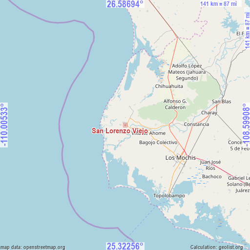
San Lorenzo Viejo GPS coordinates[2]
25° 57' 23.22" North, 109° 18' 7.92" West
| Map corner | latitude | longitude |
|---|---|---|
| Upper-left | 26.58694°, | -110.00533° |
| Center: | 25.95645°, | -109.3022° |
| Lower-right: | 25.32256°, | -108.59908° |
| Map W x H: | 140.6×140.6 km | = 87.4×87.4mi |
| max Lat: | 32.7° ⇑4.8% North |
| San Lorenzo Viejo: | 25.95645° |
| min Lat: | ⇓95.2% South 14.53588° |
| min Long | San Lorenzo Vie | max Long |
| -117.105° | -109.3022° | -86.73105° |
| W 2.7%⇐ | ⇒97.3% E |
Elevation
Elevation of San Lorenzo Viejo is 8 m = 26 ft, and this is 1245.7 m = 4087 ft below average elevation for this country.
| Max E: |
3497 m = 11473 ft | 98.1% |
| Avg. | 1253.7 m = 4113 ft | |
| San Lorenzo Viejo | 8 m = 26 ft | |
Min E: |
-1 m = -3 ft | 1.9% |
See also: Mexico elevation on elevation.city.
Geographical zone
San Lorenzo Viejo is located in North temperate zone (between Tropic of Cancer and the Arctic Circle). Distance of this Northern Tropic circle is 280.2 km =174.1 mi to South.| Distance of | km | miles | from San Lorenzo Viejo |
|---|---|---|---|
| North Pole | 7121 | 4424.8 | to North |
| Arctic Circle | 4515.1 | 2805.6 | to North |
| Tropic Cancer | 280.2 | 174.1 | to South |
| Equator | 2886.1 | 1793.3 | to South |


Nearby cities:
15 places around San Lorenzo Viejo: (largest is in red/bold)
• Ahome
13.5 km =8.4 mi,  107°
107°
• Ejido Cohuibampo
14.4 km =8.9 mi,  96°
96°
• Ejido Mayocoba
8.3 km =5.2 mi, 104°
• El Aguajito
2.8 km =1.7 mi,  277°
277°
• El Bule
8.2 km =5.1 mi,  172°
172°
• El Guayabo
16.4 km =10.2 mi, 95°
• El Refugio
4.4 km =2.7 mi,  2°
2°
• Heriberto Valdez Romero (El Guayabo)
16.6 km =10.3 mi, 96°
• Higuera de Zaragoza
1.4 km =0.9 mi,  351°
351°
• La Despensa
4.9 km =3 mi,  37°
37°
• Las Grullas Margen Derecha
9.4 km =5.8 mi,  202°
202°
• Las Grullas Margen Izquierda
11.8 km =7.3 mi,  193°
193°
• Los Suárez
11.2 km =7 mi,  92°
92°
• San Isidro
5.6 km =3.5 mi,  65°
65°
• San Pablo
10.7 km =6.6 mi,  13°
13°
Sources, notices
• [Note1] Compared only with cities in Mexico existing in our database
• [Src1] Map data: © OpenStreetMap contributors (CC-BY-SA)
• [Src2] Other city data from geonames.org with taken over terms of usage.
• [Src3] Geographical zone / Annual Mean Temperature by Robert A. Rohde @ Wikipedia
