Orranteño geodata
Orranteño (Chihuahua) is a populated place; located in Mexico in America/Chihuahua (GMT-6) time zone. With population of 1,641 people, there are 5282 cities with bigger population in this country. Compared to other cities in Mexico, 97.4% of cities are located further ↓South; 92.8% of cities are located further →East and 55.7% of cities have higher elevation than Orranteño. Note1


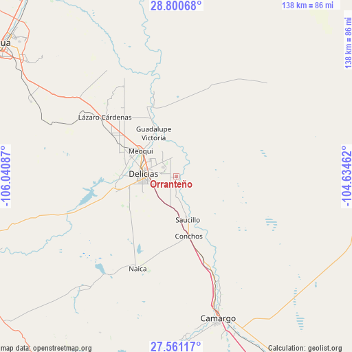
Orranteño GPS coordinates[2]
28° 10' 57.792" North, 105° 20' 15.864" West
| Map corner | latitude | longitude |
|---|---|---|
| Upper-left | 28.80068°, | -106.04087° |
| Center: | 28.18272°, | -105.33774° |
| Lower-right: | 27.56117°, | -104.63462° |
| Map W x H: | 137.8×137.8 km | = 85.6×85.6mi |
| max Lat: | 32.7° ⇑2.6% North |
| Orranteño: | 28.18272° |
| min Lat: | ⇓97.4% South 14.53588° |
| min Long | Orranteño | max Long |
| -117.105° | -105.33774° | -86.73105° |
| W 7.2%⇐ | ⇒92.8% E |
Elevation
Elevation of Orranteño is 1171 m = 3842 ft, and this is 82.7 m = 271 ft below average elevation for this country.
| Max E: |
3497 m = 11473 ft | 55.7% |
| Avg. | 1253.7 m = 4113 ft | |
| Orranteño | 1171 m = 3842 ft | |
Min E: |
-1 m = -3 ft | 44.3% |
See also: Mexico elevation on elevation.city.
Geographical zone
Orranteño is located in North temperate zone (between Tropic of Cancer and the Arctic Circle). Distance of this Northern Tropic circle is 527.7 km =327.9 mi to South.| Distance of | km | miles | from Orranteño |
|---|---|---|---|
| North Pole | 6873.4 | 4270.9 | to North |
| Arctic Circle | 4267.5 | 2651.7 | to North |
| Tropic Cancer | 527.7 | 327.9 | to South |
| Equator | 3133.6 | 1947.1 | to South |


Nearby cities:
15 places around Orranteño: (largest is in red/bold)
• Alvareñas
6.5 km =4 mi,  180°
180°
• Ciudad Delicias
13 km =8.1 mi,  273°
273°
• Colonia Abraham González (La Quemada)
7.3 km =4.5 mi,  291°
291°
• Colonia Revolución
12.3 km =7.6 mi,  302°
302°
• Colonia Terrazas
13.9 km =8.6 mi, 296°
• Colonia Vicente Guerrero
9.1 km =5.7 mi,  280°
280°
• Colonia Vicente Guerrero
16.7 km =10.4 mi,  172°
172°
• El Torreón
17.6 km =10.9 mi,  334°
334°
• Estación Saucillo
17.6 km =10.9 mi, 173°
• Las Puentes
16.6 km =10.3 mi,  319°
319°
• Las Varas
2.9 km =1.8 mi,  185°
185°
• Loma Chica
7.5 km =4.7 mi, 184°
• Meoqui
17.2 km =10.7 mi,  305°
305°
• Miguel Hidalgo
6.4 km =4 mi,  239°
239°
• Saucillo
17.5 km =10.9 mi, 165°
Sources, notices
• [Note1] Compared only with cities in Mexico existing in our database
• [Src1] Map data: © OpenStreetMap contributors (CC-BY-SA)
• [Src2] Other city data from geonames.org with taken over terms of usage.
• [Src3] Geographical zone / Annual Mean Temperature by Robert A. Rohde @ Wikipedia
