La Providencia geodata
La Providencia (Jalisco) is a populated place; located in Mexico in America/Mexico_City (GMT-6) time zone. With population of 806 people, there are 10834 cities with bigger population in this country. Compared to other cities in Mexico, 63.6% of cities are located further ↓South; 84.6% of cities are located further →East and 53% of cities have lower elevation than La Providencia. Note1


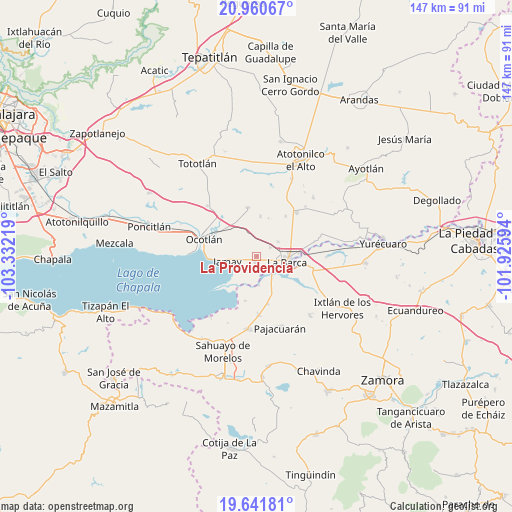
La Providencia GPS coordinates[2]
20° 18' 9.504" North, 102° 37' 44.616" West
| Map corner | latitude | longitude |
|---|---|---|
| Upper-left | 20.96067°, | -103.33219° |
| Center: | 20.30264°, | -102.62906° |
| Lower-right: | 19.64181°, | -101.92594° |
| Map W x H: | 146.6×146.6 km | = 91.1×91.1mi |
| max Lat: | 32.7° ⇑36.4% North |
| La Providencia: | 20.30264° |
| min Lat: | ⇓63.6% South 14.53588° |
| min Long | La Providencia | max Long |
| -117.105° | -102.62906° | -86.73105° |
| W 15.4%⇐ | ⇒84.6% E |
Elevation
Elevation of La Providencia is 1541 m = 5056 ft, and this is 287.3 m = 943 ft above average elevation for this country.
| Max E: |
3497 m = 11473 ft | 47% |
| La Providencia | 1541 m 5056 ft | |
| Avg. | 1253.7 m = 4113 ft | |
Min E: |
-1 m = -3 ft | 53% |
See also: Mexico elevation on elevation.city.
Geographical zone
La Providencia is located in North Torrid zone (between Equator and Tropic of Cancer). Distance of this Northern Tropic circle is 348.5 km =216.5 mi to North.| Distance of | km | miles | from La Providencia |
|---|---|---|---|
| North Pole | 7749.6 | 4815.4 | to North |
| Arctic Circle | 5143.7 | 3196.1 | to North |
| Tropic Cancer | 348.5 | 216.5 | to North |
| Equator | 2257.4 | 1402.7 | to South |


Nearby cities:
15 places around La Providencia: (largest is in red/bold)
• Briseñas de Matamoros
8 km =5 mi,  118°
118°
• Cumuato
6.4 km =4 mi,  141°
141°
• El Mirto
10.6 km =6.6 mi,  55°
55°
• Guayabos
11.4 km =7.1 mi,  17°
17°
• Ibarra
8.1 km =5 mi,  176°
176°
• Jamay
8.2 km =5.1 mi,  262°
262°
• La Barca
8.9 km =5.5 mi,  100°
100°
• La Paz de Ordaz
11.3 km =7 mi,  65°
65°
• La Puerta de Guamúchil
9.4 km =5.8 mi, 73°
• Paso de Hidalgo (Paso de Álamos)
9.3 km =5.8 mi,  110°
110°
• San Agustín
1.9 km =1.2 mi,  192°
192°
• San Francisco de Rivas
7.3 km =4.5 mi,  54°
54°
• San José de las Moras
4.6 km =2.9 mi, 55°
• San Miguel de la Paz
8.3 km =5.2 mi,  335°
335°
• San Pedro de Ruíz
6.3 km =3.9 mi, 105°
Sources, notices
• [Note1] Compared only with cities in Mexico existing in our database
• [Src1] Map data: © OpenStreetMap contributors (CC-BY-SA)
• [Src2] Other city data from geonames.org with taken over terms of usage.
• [Src3] Geographical zone / Annual Mean Temperature by Robert A. Rohde @ Wikipedia
