Ibarra geodata
Ibarra (Michoacán) is a populated place; located in Mexico in America/Mexico_City (GMT-6) time zone. With population of 1,799 people, there are 4838 cities with bigger population in this country. Compared to other cities in Mexico, 62.1% of cities are located further ↓South; 84.6% of cities are located further →East and 52.1% of cities have lower elevation than Ibarra. Note1


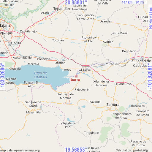
Ibarra GPS coordinates[2]
20° 13' 46.812" North, 102° 37' 25.428" West
| Map corner | latitude | longitude |
|---|---|---|
| Upper-left | 20.88801°, | -103.32686° |
| Center: | 20.22967°, | -102.62373° |
| Lower-right: | 19.56853°, | -101.92061° |
| Map W x H: | 146.7×146.7 km | = 91.2×91.2mi |
| max Lat: | 32.7° ⇑37.9% North |
| Ibarra: | 20.22967° |
| min Lat: | ⇓62.1% South 14.53588° |
| min Long | Ibarra | max Long |
| -117.105° | -102.62373° | -86.73105° |
| W 15.4%⇐ | ⇒84.6% E |
Elevation
Elevation of Ibarra is 1527 m = 5010 ft, and this is 273.3 m = 897 ft above average elevation for this country.
| Max E: |
3497 m = 11473 ft | 47.9% |
| Ibarra | 1527 m 5010 ft | |
| Avg. | 1253.7 m = 4113 ft | |
Min E: |
-1 m = -3 ft | 52.1% |
See also: Mexico elevation on elevation.city.
Geographical zone
Ibarra is located in North Torrid zone (between Equator and Tropic of Cancer). Distance of this Northern Tropic circle is 356.6 km =221.6 mi to North.| Distance of | km | miles | from Ibarra |
|---|---|---|---|
| North Pole | 7757.7 | 4820.4 | to North |
| Arctic Circle | 5151.8 | 3201.2 | to North |
| Tropic Cancer | 356.6 | 221.6 | to North |
| Equator | 2249.3 | 1397.6 | to South |


Nearby cities:
15 places around Ibarra: (largest is in red/bold)
• Briseñas de Matamoros
7.7 km =4.8 mi,  56°
56°
• Cumuato
4.6 km =2.9 mi,  48°
48°
• El Fortín
6 km =3.7 mi,  156°
156°
• Jamay
11.3 km =7 mi,  309°
309°
• La Barca
10.4 km =6.5 mi, 51°
• La Magdalena
6.1 km =3.8 mi,  220°
220°
• La Providencia
8.1 km =5 mi,  356°
356°
• Morelos
8.9 km =5.5 mi,  179°
179°
• Paso de Hidalgo (Paso de Álamos)
9.5 km =5.9 mi, 59°
• Pueblo Viejo
11.6 km =7.2 mi,  171°
171°
• San Agustín
6.3 km =3.9 mi,  351°
351°
• San Gregorio
8.7 km =5.4 mi,  116°
116°
• San José de las Moras
11.2 km =7 mi,  16°
16°
• San Pedro de Ruíz
8.4 km =5.2 mi,  40°
40°
• Venustiano Carranza
13.1 km =8.1 mi,  193°
193°
Sources, notices
• [Note1] Compared only with cities in Mexico existing in our database
• [Src1] Map data: © OpenStreetMap contributors (CC-BY-SA)
• [Src2] Other city data from geonames.org with taken over terms of usage.
• [Src3] Geographical zone / Annual Mean Temperature by Robert A. Rohde @ Wikipedia
