Pozos geodata
Pozos (Guanajuato) is a populated place; located in Mexico in America/Mexico_City (GMT-6) time zone. With population of 2,742 people, there are 3228 cities with bigger population in this country. Compared to other cities in Mexico, 70.4% of cities are located further ↓South; 72.6% of cities are located further →East and 62.4% of cities have lower elevation than Pozos. Note1


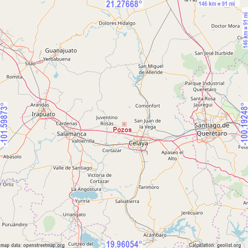
Pozos GPS coordinates[2]
20° 37' 12.108" North, 100° 53' 44.16" West
| Map corner | latitude | longitude |
|---|---|---|
| Upper-left | 21.27668°, | -101.59873° |
| Center: | 20.62003°, | -100.8956° |
| Lower-right: | 19.96054°, | -100.19248° |
| Map W x H: | 146.3×146.3 km | = 90.9×90.9mi |
| max Lat: | 32.7° ⇑29.6% North |
| Pozos: | 20.62003° |
| min Lat: | ⇓70.4% South 14.53588° |
| min Long | Pozos | max Long |
| -117.105° | -100.8956° | -86.73105° |
| W 27.4%⇐ | ⇒72.6% E |
Elevation
Elevation of Pozos is 1767 m = 5797 ft, and this is 513.3 m = 1684 ft above average elevation for this country.
| Max E: |
3497 m = 11473 ft | 37.6% |
| Pozos | 1767 m 5797 ft | |
| Avg. | 1253.7 m = 4113 ft | |
Min E: |
-1 m = -3 ft | 62.4% |
See also: Mexico elevation on elevation.city.
Geographical zone
Pozos is located in North Torrid zone (between Equator and Tropic of Cancer). Distance of this Northern Tropic circle is 313.2 km =194.6 mi to North.| Distance of | km | miles | from Pozos |
|---|---|---|---|
| North Pole | 7714.3 | 4793.4 | to North |
| Arctic Circle | 5108.4 | 3174.2 | to North |
| Tropic Cancer | 313.2 | 194.6 | to North |
| Equator | 2292.7 | 1424.6 | to South |


Nearby cities:
15 places around Pozos: (largest is in red/bold)
• Fraccionamiento el Álamo
7.5 km =4.7 mi,  180°
180°
• Franco Tavera
3.6 km =2.2 mi,  244°
244°
• Gasca
4.4 km =2.7 mi,  113°
113°
• Puerta del Monte (Elguera)
6.5 km =4 mi,  171°
171°
• Rincón del Centeno
4.7 km =2.9 mi,  13°
13°
• Roque
7.4 km =4.6 mi,  124°
124°
• San Antonio de Romerillo
5.7 km =3.5 mi,  256°
256°
• San Antonio de los Morales
4.6 km =2.9 mi,  199°
199°
• San Elías
5.9 km =3.7 mi,  73°
73°
• San José de Guanajuato
7.1 km =4.4 mi, 177°
• San José de Manantiales
2.9 km =1.8 mi,  213°
213°
• San Juan de la Cruz
2.4 km =1.5 mi,  315°
315°
• Santa Rosa los Angeles
6.7 km =4.2 mi, 205°
• Santa Teresa
4.5 km =2.8 mi,  62°
62°
• Yustis
5.3 km =3.3 mi,  141°
141°
Sources, notices
• [Note1] Compared only with cities in Mexico existing in our database
• [Src1] Map data: © OpenStreetMap contributors (CC-BY-SA)
• [Src2] Other city data from geonames.org with taken over terms of usage.
• [Src3] Geographical zone / Annual Mean Temperature by Robert A. Rohde @ Wikipedia
