Gasca geodata
Gasca (Guanajuato) is a populated place; located in Mexico in America/Mexico_City (GMT-6) time zone. With population of 1,843 people, there are 4715 cities with bigger population in this country. Compared to other cities in Mexico, 70.1% of cities are located further ↓South; 72.3% of cities are located further →East and 62.4% of cities have lower elevation than Gasca. Note1


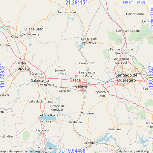
Gasca GPS coordinates[2]
20° 36' 15.984" North, 100° 51' 23.004" West
| Map corner | latitude | longitude |
|---|---|---|
| Upper-left | 21.26115°, | -101.55952° |
| Center: | 20.60444°, | -100.85639° |
| Lower-right: | 19.94488°, | -100.15327° |
| Map W x H: | 146.4×146.4 km | = 91×91mi |
| max Lat: | 32.7° ⇑29.9% North |
| Gasca: | 20.60444° |
| min Lat: | ⇓70.1% South 14.53588° |
| min Long | Gasca | max Long |
| -117.105° | -100.85639° | -86.73105° |
| W 27.7%⇐ | ⇒72.3% E |
Elevation
Elevation of Gasca is 1765 m = 5791 ft, and this is 511.3 m = 1677 ft above average elevation for this country.
| Max E: |
3497 m = 11473 ft | 37.6% |
| Gasca | 1765 m 5791 ft | |
| Avg. | 1253.7 m = 4113 ft | |
Min E: |
-1 m = -3 ft | 62.4% |
See also: Mexico elevation on elevation.city.
Geographical zone
Gasca is located in North Torrid zone (between Equator and Tropic of Cancer). Distance of this Northern Tropic circle is 314.9 km =195.7 mi to North.| Distance of | km | miles | from Gasca |
|---|---|---|---|
| North Pole | 7716.1 | 4794.6 | to North |
| Arctic Circle | 5110.2 | 3175.3 | to North |
| Tropic Cancer | 314.9 | 195.7 | to North |
| Equator | 2291 | 1423.6 | to South |


Nearby cities:
15 places around Gasca: (largest is in red/bold)
• La Concepción
6.6 km =4.1 mi,  79°
79°
• Plancarte
6.6 km =4.1 mi,  107°
107°
• Pozos
4.4 km =2.7 mi,  293°
293°
• Puerta del Monte (Elguera)
5.6 km =3.5 mi,  213°
213°
• Rincón del Centeno
6.9 km =4.3 mi,  334°
334°
• Roque
3.2 km =2 mi,  141°
141°
• San Antonio de los Morales
6.2 km =3.9 mi,  244°
244°
• San Cayetano
3.8 km =2.4 mi,  91°
91°
• San Elías
3.8 km =2.4 mi,  24°
24°
• San José de Guanajuato
6.6 km =4.1 mi,  215°
215°
• San José de Manantiales
5.7 km =3.5 mi,  263°
263°
• San Juan de la Cruz
6.7 km =4.2 mi,  300°
300°
• Santa Teresa
3.8 km =2.4 mi,  358°
358°
• Tenería del Santuario
6.1 km =3.8 mi,  95°
95°
• Yustis
2.6 km =1.6 mi,  197°
197°
Sources, notices
• [Note1] Compared only with cities in Mexico existing in our database
• [Src1] Map data: © OpenStreetMap contributors (CC-BY-SA)
• [Src2] Other city data from geonames.org with taken over terms of usage.
• [Src3] Geographical zone / Annual Mean Temperature by Robert A. Rohde @ Wikipedia
