San Elías geodata
San Elías (Guanajuato) is a populated place; located in Mexico in America/Mexico_City (GMT-6) time zone. With population of 2,200 people, there are 3989 cities with bigger population in this country. Compared to other cities in Mexico, 70.6% of cities are located further ↓South; 72.2% of cities are located further →East and 63.1% of cities have lower elevation than San Elías. Note1


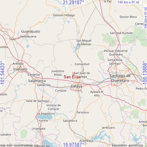
San Elías GPS coordinates[2]
20° 38' 7.044" North, 100° 50' 28.32" West
| Map corner | latitude | longitude |
|---|---|---|
| Upper-left | 21.29187°, | -101.54433° |
| Center: | 20.63529°, | -100.8412° |
| Lower-right: | 19.97587°, | -100.13808° |
| Map W x H: | 146.3×146.3 km | = 90.9×90.9mi |
| max Lat: | 32.7° ⇑29.4% North |
| San Elías: | 20.63529° |
| min Lat: | ⇓70.6% South 14.53588° |
| min Long | San Elías | max Long |
| -117.105° | -100.8412° | -86.73105° |
| W 27.8%⇐ | ⇒72.2% E |
Elevation
Elevation of San Elías is 1780 m = 5840 ft, and this is 526.3 m = 1727 ft above average elevation for this country.
| Max E: |
3497 m = 11473 ft | 36.9% |
| San Elías | 1780 m 5840 ft | |
| Avg. | 1253.7 m = 4113 ft | |
Min E: |
-1 m = -3 ft | 63.1% |
See also: Mexico elevation on elevation.city.
Geographical zone
San Elías is located in North Torrid zone (between Equator and Tropic of Cancer). Distance of this Northern Tropic circle is 311.5 km =193.6 mi to North.| Distance of | km | miles | from San Elías |
|---|---|---|---|
| North Pole | 7712.6 | 4792.4 | to North |
| Arctic Circle | 5106.7 | 3173.2 | to North |
| Tropic Cancer | 311.5 | 193.6 | to North |
| Equator | 2294.4 | 1425.7 | to South |


Nearby cities:
15 places around San Elías: (largest is in red/bold)
• Gasca
3.8 km =2.4 mi,  204°
204°
• La Concepción
5.3 km =3.3 mi,  114°
114°
• Plancarte
7.1 km =4.4 mi,  139°
139°
• Pozos
5.9 km =3.7 mi,  253°
253°
• Presa Blanca
5.1 km =3.2 mi,  82°
82°
• Rincón del Centeno
5.4 km =3.4 mi,  301°
301°
• Roque
5.9 km =3.7 mi,  176°
176°
• San Antonio Espinoza
5.1 km =3.2 mi,  67°
67°
• San Antonio Gallardo
7.7 km =4.8 mi,  95°
95°
• San Cayetano
4.1 km =2.5 mi,  148°
148°
• San Isidro de la Concepción
5.8 km =3.6 mi, 98°
• San Juan de la Cruz
7.4 km =4.6 mi,  270°
270°
• Santa Teresa
1.7 km =1.1 mi,  281°
281°
• Tenería del Santuario
6 km =3.7 mi,  131°
131°
• Yustis
6.3 km =3.9 mi, 201°
Sources, notices
• [Note1] Compared only with cities in Mexico existing in our database
• [Src1] Map data: © OpenStreetMap contributors (CC-BY-SA)
• [Src2] Other city data from geonames.org with taken over terms of usage.
• [Src3] Geographical zone / Annual Mean Temperature by Robert A. Rohde @ Wikipedia
