Nogales geodata
Nogales (Durango) is a populated place; located in Mexico in America/Monterrey (GMT-6) time zone. With population of 1,117 people, there are 7781 cities with bigger population in this country. Compared to other cities in Mexico, 91.8% of cities are located further ↓South; 91.5% of cities are located further →East and 69% of cities have lower elevation than Nogales. Note1


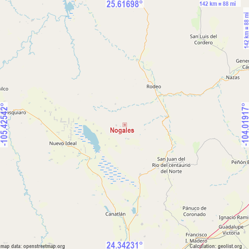
Nogales GPS coordinates[2]
24° 58' 52.68" North, 104° 43' 20.244" West
| Map corner | latitude | longitude |
|---|---|---|
| Upper-left | 25.61698°, | -105.42542° |
| Center: | 24.9813°, | -104.72229° |
| Lower-right: | 24.34231°, | -104.01917° |
| Map W x H: | 141.7×141.7 km | = 88×88mi |
| max Lat: | 32.7° ⇑8.2% North |
| Nogales: | 24.9813° |
| min Lat: | ⇓91.8% South 14.53588° |
| min Long | Nogales | max Long |
| -117.105° | -104.72229° | -86.73105° |
| W 8.5%⇐ | ⇒91.5% E |
Elevation
Elevation of Nogales is 1907 m = 6257 ft, and this is 653.3 m = 2143 ft above average elevation for this country.
| Max E: |
3497 m = 11473 ft | 31% |
| Nogales | 1907 m 6257 ft | |
| Avg. | 1253.7 m = 4113 ft | |
Min E: |
-1 m = -3 ft | 69% |
See also: Mexico elevation on elevation.city.
Geographical zone
Nogales is located in North temperate zone (between Tropic of Cancer and the Arctic Circle). Distance of this Northern Tropic circle is 171.7 km =106.7 mi to South.| Distance of | km | miles | from Nogales |
|---|---|---|---|
| North Pole | 7229.4 | 4492.1 | to North |
| Arctic Circle | 4623.5 | 2872.9 | to North |
| Tropic Cancer | 171.7 | 106.7 | to South |
| Equator | 2777.7 | 1726 | to South |


Nearby cities:
15 places around Nogales: (largest is in red/bold)
• Ciénega Grande
31.1 km =19.3 mi,  142°
142°
• Coneto de Comonfort
4.9 km =3 mi,  269°
269°
• Diez de Octubre
29.4 km =18.3 mi,  162°
162°
• Doctor Castillo del Valle
22.4 km =13.9 mi,  277°
277°
• El Nuevo Porvenir
28.7 km =17.8 mi,  240°
240°
• Esfuerzos Unidos
32.3 km =20.1 mi, 236°
• Francisco Primo Verdad
28.2 km =17.5 mi,  107°
107°
• Guatimapé
27.8 km =17.3 mi,  225°
225°
• José María Patoni
30.1 km =18.7 mi, 112°
• La Soledad
32 km =19.9 mi,  220°
220°
• Miguel Negrete
26.5 km =16.5 mi, 278°
• Nuevo Ideal
37.2 km =23.1 mi,  253°
253°
• Rodeo
27.4 km =17 mi,  36°
36°
• San Juan del Rio del Centauro del Norte
34.9 km =21.7 mi,  130°
130°
• Santa Bárbara
32.2 km =20 mi,  27°
27°
Sources, notices
• [Note1] Compared only with cities in Mexico existing in our database
• [Src1] Map data: © OpenStreetMap contributors (CC-BY-SA)
• [Src2] Other city data from geonames.org with taken over terms of usage.
• [Src3] Geographical zone / Annual Mean Temperature by Robert A. Rohde @ Wikipedia
