Navolato geodata
Navolato (Sinaloa) is a seat of a second-order administrative division; located in Mexico in America/Mazatlan (GMT-7) time zone. With population of 29,153 people, there are 344 cities with bigger population in this country. Compared to other cities in Mexico, 91.4% of cities are located further ↓South; 95.3% of cities are located further →East and 92.5% of cities have higher elevation than Navolato. Note1


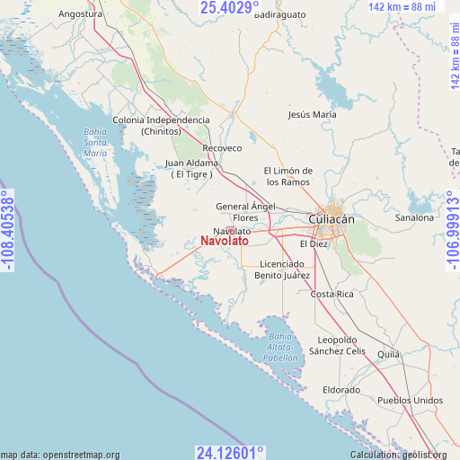
Navolato GPS coordinates[2]
24° 45' 57.96" North, 107° 42' 8.1" West
| Map corner | latitude | longitude |
|---|---|---|
| Upper-left | 25.4029°, | -108.40538° |
| Center: | 24.7661°, | -107.70225° |
| Lower-right: | 24.12601°, | -106.99913° |
| Map W x H: | 142×142 km | = 88.2×88.2mi |
| max Lat: | 32.7° ⇑8.6% North |
| Navolato: | 24.7661° |
| min Lat: | ⇓91.4% South 14.53588° |
| min Long | Navolato | max Long |
| -117.105° | -107.70225° | -86.73105° |
| W 4.7%⇐ | ⇒95.3% E |
Elevation
Elevation of Navolato is 18 m = 59 ft, and this is 1235.7 m = 4054 ft below average elevation for this country.
| Max E: |
3497 m = 11473 ft | 92.5% |
| Avg. | 1253.7 m = 4113 ft | |
| Navolato | 18 m = 59 ft | |
Min E: |
-1 m = -3 ft | 7.5% |
See also: Mexico elevation on elevation.city.
Geographical zone
Navolato is located in North temperate zone (between Tropic of Cancer and the Arctic Circle). Distance of this Northern Tropic circle is 147.8 km =91.8 mi to South.| Distance of | km | miles | from Navolato |
|---|---|---|---|
| North Pole | 7253.3 | 4507 | to North |
| Arctic Circle | 4647.4 | 2887.8 | to North |
| Tropic Cancer | 147.8 | 91.8 | to South |
| Equator | 2753.7 | 1711.1 | to South |


Nearby cities:
15 places around Navolato: (largest is in red/bold)
• Bachimeto
5 km =3.1 mi,  237°
237°
• Bariometo
4 km =2.5 mi,  88°
88°
• Cofradía de Navolato (Cofradía de los Rocha)
5.5 km =3.4 mi, 87°
• Colonia Michoacana
8.5 km =5.3 mi,  122°
122°
• Ejido Convención de Aguascalientes
7.1 km =4.4 mi,  97°
97°
• Ejido la Paloma
9.6 km =6 mi,  29°
29°
• El Potrero de Sataya
8.5 km =5.3 mi,  184°
184°
• General Ángel Flores (La Palma)
7.5 km =4.7 mi,  37°
37°
• La Sinaloa
7.9 km =4.9 mi, 89°
• La Vuelta
5.7 km =3.5 mi, 184°
• Las Trancas
7 km =4.3 mi,  215°
215°
• Lo de Reyes
7 km =4.3 mi,  263°
263°
• Lo de Sauceda
9.4 km =5.8 mi,  66°
66°
• Otameto
5.6 km =3.5 mi, 222°
• Tabolato
2.7 km =1.7 mi,  233°
233°
Sources, notices
• [Note1] Compared only with cities in Mexico existing in our database
• [Src1] Map data: © OpenStreetMap contributors (CC-BY-SA)
• [Src2] Other city data from geonames.org with taken over terms of usage.
• [Src3] Geographical zone / Annual Mean Temperature by Robert A. Rohde @ Wikipedia
