San Pedro Garza Garcia geodata
San Pedro Garza Garcia (Nuevo León) is a populated place; located in Mexico in America/Monterrey (GMT-6) time zone. With population of 122,009 people, there are 117 cities with bigger population in this country. Compared to other cities in Mexico, 93.4% of cities are located further ↓South; 68.5% of cities are located further →East and 65.5% of cities have higher elevation than San Pedro Garza Garcia. Note1
Current local time in San Pedro Garza Garcia:
06:46 AM, WednesdayDifference from your time zone: hours


San Pedro Garza Garcia GPS coordinates[2]
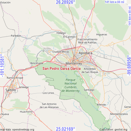
25° 39' 25.776" North, 100° 24' 9.648" West
| Map corner | latitude | longitude |
|---|---|---|
| Upper-left | 26.28926°, | -101.10581° |
| Center: | 25.65716°, | -100.40268° |
| Lower-right: | 25.02169°, | -99.69956° |
| Map W x H: | 140.9×140.9 km | = 87.6×87.6mi |
| max Lat: | 32.7° ⇑6.6% North |
| San Pedro Garza Garcia: | 25.65716° |
| min Lat: | ⇓93.4% South 14.53588° |
| min Long | San Pedro Garza | max Long |
| -117.105° | -100.40268° | -86.73105° |
| W 31.5%⇐ | ⇒68.5% E |
Elevation
Elevation of San Pedro Garza Garcia is 663 m = 2175 ft, and this is 590.7 m = 1938 ft below average elevation for this country.
| Max E: |
3497 m = 11473 ft | 65.5% |
| Avg. | 1253.7 m = 4113 ft | |
| San Pedro Garza Garcia | 663 m = 2175 ft | |
Min E: |
-1 m = -3 ft | 34.5% |
See also: San Pedro Garza Garcia elevation on elevation.city.
Geographical zone
San Pedro Garza Garcia is located in North temperate zone (between Tropic of Cancer and the Arctic Circle). Distance of this Northern Tropic circle is 246.9 km =153.4 mi to South.| Distance of | km | miles | from San Pedro Garza Garcia |
|---|---|---|---|
| North Pole | 7154.3 | 4445.5 | to North |
| Arctic Circle | 4548.4 | 2826.2 | to North |
| Tropic Cancer | 246.9 | 153.4 | to South |
| Equator | 2852.8 | 1772.6 | to South |


Nearby cities:
15 places around San Pedro Garza Garcia: (largest is in red/bold)
• Alianza Real
21.7 km =13.5 mi,  5°
5°
• Ciudad General Escobedo
17.7 km =11 mi,  28°
28°
• Guadalupe
14.8 km =9.2 mi,  81°
81°
• Los Parques
16.3 km =10.1 mi,  335°
335°
• Mitras Poniente
13.4 km =8.3 mi,  350°
350°
• Monclova Primer Sector
17.5 km =10.9 mi,  359°
359°
• Monclova Segundo Sector
17.6 km =10.9 mi,  1°
1°
• Monterrey
8.7 km =5.4 mi, 76°
• Parque Industrial Ciudad Mitras
15.3 km =9.5 mi, 342°
• Praderas de San Francisco
17.9 km =11.1 mi, 0°
• San Nicolás de los Garza
13.8 km =8.6 mi,  46°
46°
• San Pedro Garza García
0.5 km =0.3 mi,  313°
313°
• Santa Catarina
5.8 km =3.6 mi,  287°
287°
• Unión Agropecuarios Lázaro Cárdenas del Norte
19.6 km =12.2 mi, 5°
• Valle de Lincoln
16.9 km =10.5 mi,  333°
333°
Sources, notices
• [Note1] Compared only with cities in Mexico existing in our database
• [Src1] Map data: © OpenStreetMap contributors (CC-BY-SA)
• [Src2] Other city data from geonames.org with taken over terms of usage.
• [Src3] Geographical zone / Annual Mean Temperature by Robert A. Rohde @ Wikipedia
