Menores geodata
Menores (Guanajuato) is a populated place; located in Mexico in America/Mexico_City (GMT-6) time zone. With population of 1,217 people, there are 7142 cities with bigger population in this country. Compared to other cities in Mexico, 75.2% of cities are located further ↓South; 76.4% of cities are located further →East and 62.9% of cities have lower elevation than Menores. Note1


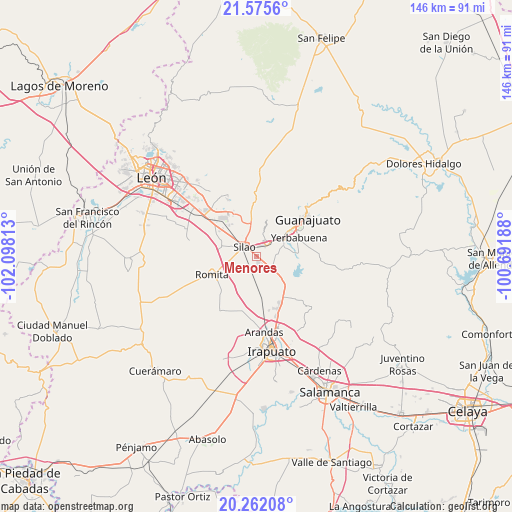
Menores GPS coordinates[2]
20° 55' 13.008" North, 101° 23' 42" West
| Map corner | latitude | longitude |
|---|---|---|
| Upper-left | 21.5756°, | -102.09813° |
| Center: | 20.92028°, | -101.395° |
| Lower-right: | 20.26208°, | -100.69188° |
| Map W x H: | 146×146.1 km | = 90.7×90.8mi |
| max Lat: | 32.7° ⇑24.8% North |
| Menores: | 20.92028° |
| min Lat: | ⇓75.2% South 14.53588° |
| min Long | Menores | max Long |
| -117.105° | -101.395° | -86.73105° |
| W 23.6%⇐ | ⇒76.4% E |
Elevation
Elevation of Menores is 1777 m = 5830 ft, and this is 523.3 m = 1717 ft above average elevation for this country.
| Max E: |
3497 m = 11473 ft | 37.1% |
| Menores | 1777 m 5830 ft | |
| Avg. | 1253.7 m = 4113 ft | |
Min E: |
-1 m = -3 ft | 62.9% |
See also: Mexico elevation on elevation.city.
Geographical zone
Menores is located in North Torrid zone (between Equator and Tropic of Cancer). Distance of this Northern Tropic circle is 279.8 km =173.9 mi to North.| Distance of | km | miles | from Menores |
|---|---|---|---|
| North Pole | 7680.9 | 4772.7 | to North |
| Arctic Circle | 5075.1 | 3153.5 | to North |
| Tropic Cancer | 279.8 | 173.9 | to North |
| Equator | 2326.1 | 1445.4 | to South |


Nearby cities:
15 places around Menores: (largest is in red/bold)
• Aguas Buenas
6 km =3.7 mi,  22°
22°
• Cerritos
2.3 km =1.4 mi,  337°
337°
• El Espejo
5 km =3.1 mi,  132°
132°
• El Nuevo Condado
5.1 km =3.2 mi,  282°
282°
• El Nuevo Refugio
2.5 km =1.6 mi,  181°
181°
• La Calaverna
5.1 km =3.2 mi,  138°
138°
• La Soledad
2.4 km =1.5 mi,  229°
229°
• Los Rodríguez
3.8 km =2.4 mi,  62°
62°
• San Diego
3.9 km =2.4 mi,  203°
203°
• San Ignacio
3.8 km =2.4 mi,  99°
99°
• San Isidro del Arenal
4.8 km =3 mi,  249°
249°
• San José de Gracia
5.9 km =3.7 mi, 245°
• San Marcos
5.6 km =3.5 mi,  70°
70°
• Silao
4.2 km =2.6 mi,  307°
307°
• Villas de Guadalupe
3.4 km =2.1 mi, 343°
Sources, notices
• [Note1] Compared only with cities in Mexico existing in our database
• [Src1] Map data: © OpenStreetMap contributors (CC-BY-SA)
• [Src2] Other city data from geonames.org with taken over terms of usage.
• [Src3] Geographical zone / Annual Mean Temperature by Robert A. Rohde @ Wikipedia
