Villas de Guadalupe geodata
Villas de Guadalupe (Guanajuato) is a populated place; located in Mexico in America/Mexico_City (GMT-6) time zone. With population of 640 people, there are 13529 cities with bigger population in this country. Compared to other cities in Mexico, 75.7% of cities are located further ↓South; 76.5% of cities are located further →East and 63.3% of cities have lower elevation than Villas de Guadalupe. Note1


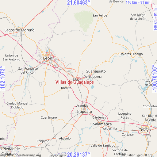
Villas de Guadalupe GPS coordinates[2]
20° 56' 57.984" North, 101° 24' 15.012" West
| Map corner | latitude | longitude |
|---|---|---|
| Upper-left | 21.60463°, | -102.1073° |
| Center: | 20.94944°, | -101.40417° |
| Lower-right: | 20.29137°, | -100.70105° |
| Map W x H: | 146×146 km | = 90.7×90.7mi |
| max Lat: | 32.7° ⇑24.3% North |
| Villas de Guadalupe: | 20.94944° |
| min Lat: | ⇓75.7% South 14.53588° |
| min Long | Villas de Guada | max Long |
| -117.105° | -101.40417° | -86.73105° |
| W 23.5%⇐ | ⇒76.5% E |
Elevation
Elevation of Villas de Guadalupe is 1783 m = 5850 ft, and this is 529.3 m = 1737 ft above average elevation for this country.
| Max E: |
3497 m = 11473 ft | 36.7% |
| Villas de Guadalupe | 1783 m 5850 ft | |
| Avg. | 1253.7 m = 4113 ft | |
Min E: |
-1 m = -3 ft | 63.3% |
See also: Mexico elevation on elevation.city.
Geographical zone
Villas de Guadalupe is located in North Torrid zone (between Equator and Tropic of Cancer). Distance of this Northern Tropic circle is 276.6 km =171.9 mi to North.| Distance of | km | miles | from Villas de Guadalupe |
|---|---|---|---|
| North Pole | 7677.7 | 4770.7 | to North |
| Arctic Circle | 5071.8 | 3151.5 | to North |
| Tropic Cancer | 276.6 | 171.9 | to North |
| Equator | 2329.4 | 1447.4 | to South |


Nearby cities:
15 places around Villas de Guadalupe: (largest is in red/bold)
• Aguas Buenas
4 km =2.5 mi,  54°
54°
• Cerritos
1.1 km =0.7 mi,  175°
175°
• Colonia Francisco Javier Mina
3.6 km =2.2 mi,  339°
339°
• El Coecillo
5.6 km =3.5 mi,  302°
302°
• El Nuevo Condado
4.6 km =2.9 mi,  242°
242°
• El Nuevo Refugio
5.8 km =3.6 mi,  171°
171°
• Franco
6 km =3.7 mi,  263°
263°
• La Soledad
4.9 km =3 mi,  189°
189°
• Los Rodríguez
4.6 km =2.9 mi,  108°
108°
• Menores
3.4 km =2.1 mi,  163°
163°
• Monte del Coecillo
4.6 km =2.9 mi,  315°
315°
• Pabileros
4.4 km =2.7 mi,  8°
8°
• Rancho Seco
4.8 km =3 mi, 344°
• Silao
2.5 km =1.6 mi,  254°
254°
• Velarde
5.6 km =3.5 mi, 6°
Sources, notices
• [Note1] Compared only with cities in Mexico existing in our database
• [Src1] Map data: © OpenStreetMap contributors (CC-BY-SA)
• [Src2] Other city data from geonames.org with taken over terms of usage.
• [Src3] Geographical zone / Annual Mean Temperature by Robert A. Rohde @ Wikipedia
