Los Hernández geodata
Los Hernández (Guanajuato) is a populated place; located in Mexico in America/Mexico_City (GMT-6) time zone. With population of 626 people, there are 13818 cities with bigger population in this country. Compared to other cities in Mexico, 71.5% of cities are located further ↓South; 74.5% of cities are located further →East and 65.9% of cities have lower elevation than Los Hernández. Note1


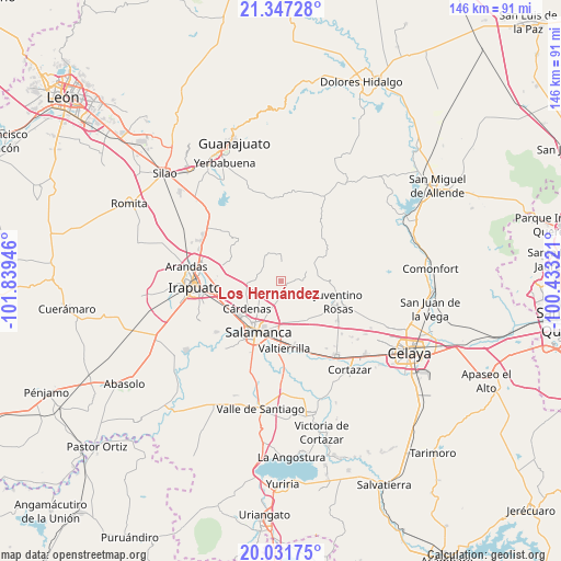
Los Hernández GPS coordinates[2]
20° 41' 27.384" North, 101° 8' 10.788" West
| Map corner | latitude | longitude |
|---|---|---|
| Upper-left | 21.34728°, | -101.83946° |
| Center: | 20.69094°, | -101.13633° |
| Lower-right: | 20.03175°, | -100.43321° |
| Map W x H: | 146.3×146.3 km | = 90.9×90.9mi |
| max Lat: | 32.7° ⇑28.5% North |
| Los Hernández: | 20.69094° |
| min Lat: | ⇓71.5% South 14.53588° |
| min Long | Los Hernández | max Long |
| -117.105° | -101.13633° | -86.73105° |
| W 25.5%⇐ | ⇒74.5% E |
Elevation
Elevation of Los Hernández is 1848 m = 6063 ft, and this is 594.3 m = 1950 ft above average elevation for this country.
| Max E: |
3497 m = 11473 ft | 34.1% |
| Los Hernández | 1848 m 6063 ft | |
| Avg. | 1253.7 m = 4113 ft | |
Min E: |
-1 m = -3 ft | 65.9% |
See also: Mexico elevation on elevation.city.
Geographical zone
Los Hernández is located in North Torrid zone (between Equator and Tropic of Cancer). Distance of this Northern Tropic circle is 305.3 km =189.7 mi to North.| Distance of | km | miles | from Los Hernández |
|---|---|---|---|
| North Pole | 7706.4 | 4788.5 | to North |
| Arctic Circle | 5100.6 | 3169.4 | to North |
| Tropic Cancer | 305.3 | 189.7 | to North |
| Equator | 2300.6 | 1429.5 | to South |


Nearby cities:
15 places around Los Hernández: (largest is in red/bold)
• Barrón
5.6 km =3.5 mi,  106°
106°
• Cerrito de Gasca
11.2 km =7 mi,  136°
136°
• Cerro Gordo
10.9 km =6.8 mi,  174°
174°
• Cárdenas
11.1 km =6.9 mi,  232°
232°
• El Recuerdo de Ancón (Xoconoxtle de Arriba)
6 km =3.7 mi, 170°
• La Ordeña
1.9 km =1.2 mi,  93°
93°
• La Purísima
11.2 km =7 mi,  126°
126°
• Las Liebres
7 km =4.3 mi, 169°
• Los Miranda (El Xoconoxtle de Abajo)
5.8 km =3.6 mi,  181°
181°
• María Gómez
4 km =2.5 mi,  81°
81°
• Mesas de Acosta
8.9 km =5.5 mi,  43°
43°
• Oteros
9.4 km =5.8 mi,  203°
203°
• Razos de Ancón
2.3 km =1.4 mi,  220°
220°
• San José de Mendoza
8 km =5 mi,  268°
268°
• San José de las Pilas
10.4 km =6.5 mi, 114°
Sources, notices
• [Note1] Compared only with cities in Mexico existing in our database
• [Src1] Map data: © OpenStreetMap contributors (CC-BY-SA)
• [Src2] Other city data from geonames.org with taken over terms of usage.
• [Src3] Geographical zone / Annual Mean Temperature by Robert A. Rohde @ Wikipedia
