La Purísima geodata
La Purísima (Guanajuato) is a populated place; located in Mexico in America/Mexico_City (GMT-6) time zone. With population of 591 people, there are 14530 cities with bigger population in this country. Compared to other cities in Mexico, 70.6% of cities are located further ↓South; 73.8% of cities are located further →East and 61.6% of cities have lower elevation than La Purísima. Note1


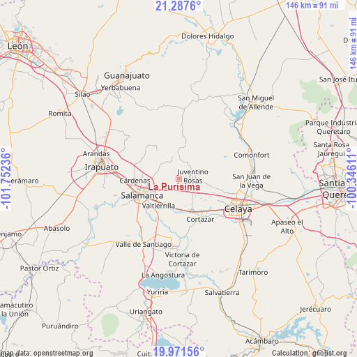
La Purísima GPS coordinates[2]
20° 37' 51.6" North, 101° 2' 57.228" West
| Map corner | latitude | longitude |
|---|---|---|
| Upper-left | 21.2876°, | -101.75236° |
| Center: | 20.631°, | -101.04923° |
| Lower-right: | 19.97156°, | -100.34611° |
| Map W x H: | 146.3×146.3 km | = 90.9×90.9mi |
| max Lat: | 32.7° ⇑29.4% North |
| La Purísima: | 20.631° |
| min Lat: | ⇓70.6% South 14.53588° |
| min Long | La Purísima | max Long |
| -117.105° | -101.04923° | -86.73105° |
| W 26.2%⇐ | ⇒73.8% E |
Elevation
Elevation of La Purísima is 1751 m = 5745 ft, and this is 497.3 m = 1632 ft above average elevation for this country.
| Max E: |
3497 m = 11473 ft | 38.4% |
| La Purísima | 1751 m 5745 ft | |
| Avg. | 1253.7 m = 4113 ft | |
Min E: |
-1 m = -3 ft | 61.6% |
See also: Mexico elevation on elevation.city.
Geographical zone
La Purísima is located in North Torrid zone (between Equator and Tropic of Cancer). Distance of this Northern Tropic circle is 312 km =193.9 mi to North.| Distance of | km | miles | from La Purísima |
|---|---|---|---|
| North Pole | 7713.1 | 4792.7 | to North |
| Arctic Circle | 5107.2 | 3173.5 | to North |
| Tropic Cancer | 312 | 193.9 | to North |
| Equator | 2294 | 1425.4 | to South |


Nearby cities:
15 places around La Purísima: (largest is in red/bold)
• Barrón
6.2 km =3.9 mi,  324°
324°
• Cerrito de Gasca
1.9 km =1.2 mi,  223°
223°
• Colonia 18 de Marzo
8.5 km =5.3 mi,  170°
170°
• El Jaralillo
8.4 km =5.2 mi,  63°
63°
• El Recuerdo de Ancón (Xoconoxtle de Arriba)
8.1 km =5 mi,  275°
275°
• Emiliano Zapata
1.5 km =0.9 mi,  158°
158°
• Juventino Rosas
6 km =3.7 mi,  76°
76°
• Las Liebres
7.8 km =4.8 mi,  268°
268°
• María Gómez
8.9 km =5.5 mi, 324°
• San José de la Montaña
4.2 km =2.6 mi, 215°
• San José de las Pilas
2.4 km =1.5 mi,  9°
9°
• Santa Rita
5.7 km =3.5 mi,  228°
228°
• Santiago de Cuenda
6.7 km =4.2 mi,  121°
121°
• Valencia de Cerro Gordo
4.7 km =2.9 mi, 225°
• Zapote de Palomas
8.6 km =5.3 mi, 232°
Sources, notices
• [Note1] Compared only with cities in Mexico existing in our database
• [Src1] Map data: © OpenStreetMap contributors (CC-BY-SA)
• [Src2] Other city data from geonames.org with taken over terms of usage.
• [Src3] Geographical zone / Annual Mean Temperature by Robert A. Rohde @ Wikipedia
