Las Liebres geodata
Las Liebres (Guanajuato) is a populated place; located in Mexico in America/Mexico_City (GMT-6) time zone. With population of 528 people, there are 16014 cities with bigger population in this country. Compared to other cities in Mexico, 70.6% of cities are located further ↓South; 74.4% of cities are located further →East and 62.1% of cities have lower elevation than Las Liebres. Note1


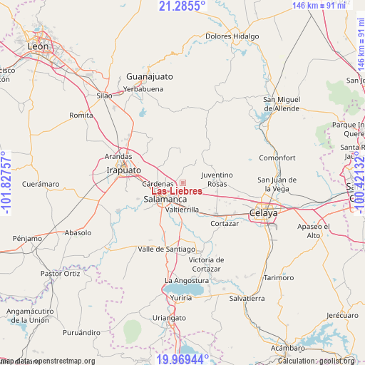
Las Liebres GPS coordinates[2]
20° 37' 44.004" North, 101° 7' 27.984" West
| Map corner | latitude | longitude |
|---|---|---|
| Upper-left | 21.2855°, | -101.82757° |
| Center: | 20.62889°, | -101.12444° |
| Lower-right: | 19.96944°, | -100.42132° |
| Map W x H: | 146.3×146.3 km | = 90.9×90.9mi |
| max Lat: | 32.7° ⇑29.4% North |
| Las Liebres: | 20.62889° |
| min Lat: | ⇓70.6% South 14.53588° |
| min Long | Las Liebres | max Long |
| -117.105° | -101.12444° | -86.73105° |
| W 25.6%⇐ | ⇒74.4% E |
Elevation
Elevation of Las Liebres is 1762 m = 5781 ft, and this is 508.3 m = 1668 ft above average elevation for this country.
| Max E: |
3497 m = 11473 ft | 37.9% |
| Las Liebres | 1762 m 5781 ft | |
| Avg. | 1253.7 m = 4113 ft | |
Min E: |
-1 m = -3 ft | 62.1% |
See also: Mexico elevation on elevation.city.
Geographical zone
Las Liebres is located in North Torrid zone (between Equator and Tropic of Cancer). Distance of this Northern Tropic circle is 312.2 km =194 mi to North.| Distance of | km | miles | from Las Liebres |
|---|---|---|---|
| North Pole | 7713.3 | 4792.8 | to North |
| Arctic Circle | 5107.5 | 3173.7 | to North |
| Tropic Cancer | 312.2 | 194 | to North |
| Equator | 2293.7 | 1425.2 | to South |


Nearby cities:
15 places around Las Liebres: (largest is in red/bold)
• Barrón
6.8 km =4.2 mi,  38°
38°
• Cerrito de Gasca
6.6 km =4.1 mi,  100°
100°
• Cerro Gordo
4 km =2.5 mi,  183°
183°
• El Divisador
6.7 km =4.2 mi,  211°
211°
• El Recuerdo de Ancón (Xoconoxtle de Arriba)
1.1 km =0.7 mi,  345°
345°
• La Ordeña
6.8 km =4.2 mi,  5°
5°
• La Purísima
7.8 km =4.8 mi,  88°
88°
• Los Hernández
7 km =4.3 mi, 349°
• Los Miranda (El Xoconoxtle de Abajo)
1.8 km =1.1 mi,  308°
308°
• Oteros
5.2 km =3.2 mi,  250°
250°
• Razos de Ancón
5.8 km =3.6 mi,  332°
332°
• San José de la Montaña
6.3 km =3.9 mi,  120°
120°
• Santa Rita
5 km =3.1 mi,  134°
134°
• Valencia de Cerro Gordo
5.4 km =3.4 mi, 124°
• Zapote de Palomas
5 km =3.1 mi,  168°
168°
Sources, notices
• [Note1] Compared only with cities in Mexico existing in our database
• [Src1] Map data: © OpenStreetMap contributors (CC-BY-SA)
• [Src2] Other city data from geonames.org with taken over terms of usage.
• [Src3] Geographical zone / Annual Mean Temperature by Robert A. Rohde @ Wikipedia
