Loma Tendida geodata
Loma Tendida (Guanajuato) is a populated place; located in Mexico in America/Mexico_City (GMT-6) time zone. With population of 1,152 people, there are 7522 cities with bigger population in this country. Compared to other cities in Mexico, 65.1% of cities are located further ↓South; 75.8% of cities are located further →East and 60.7% of cities have lower elevation than Loma Tendida. Note1


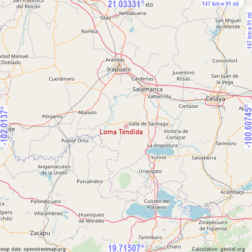
Loma Tendida GPS coordinates[2]
20° 22' 32.16" North, 101° 18' 38.052" West
| Map corner | latitude | longitude |
|---|---|---|
| Upper-left | 21.03331°, | -102.0137° |
| Center: | 20.3756°, | -101.31057° |
| Lower-right: | 19.71507°, | -100.60745° |
| Map W x H: | 146.6×146.6 km | = 91.1×91.1mi |
| max Lat: | 32.7° ⇑34.9% North |
| Loma Tendida: | 20.3756° |
| min Lat: | ⇓65.1% South 14.53588° |
| min Long | Loma Tendida | max Long |
| -117.105° | -101.31057° | -86.73105° |
| W 24.2%⇐ | ⇒75.8% E |
Elevation
Elevation of Loma Tendida is 1737 m = 5699 ft, and this is 483.3 m = 1586 ft above average elevation for this country.
| Max E: |
3497 m = 11473 ft | 39.3% |
| Loma Tendida | 1737 m 5699 ft | |
| Avg. | 1253.7 m = 4113 ft | |
Min E: |
-1 m = -3 ft | 60.7% |
See also: Mexico elevation on elevation.city.
Geographical zone
Loma Tendida is located in North Torrid zone (between Equator and Tropic of Cancer). Distance of this Northern Tropic circle is 340.4 km =211.5 mi to North.| Distance of | km | miles | from Loma Tendida |
|---|---|---|---|
| North Pole | 7741.5 | 4810.3 | to North |
| Arctic Circle | 5135.6 | 3191.1 | to North |
| Tropic Cancer | 340.4 | 211.5 | to North |
| Equator | 2265.6 | 1407.8 | to South |


Nearby cities:
15 places around Loma Tendida: (largest is in red/bold)
• Cerro Colorado
3.2 km =2 mi,  332°
332°
• Charco de Pantoja
4.8 km =3 mi,  288°
288°
• Lagunilla de Mogotes
10.3 km =6.4 mi,  149°
149°
• Mogotes de San José Parangueo
4.5 km =2.8 mi,  12°
12°
• Quiriceo
6.9 km =4.3 mi,  357°
357°
• Rancho Nuevo de San Andrés
2.8 km =1.7 mi,  86°
86°
• Rincón de Parangueo
8.1 km =5 mi,  50°
50°
• San Cristóbal
9.2 km =5.7 mi,  280°
280°
• San Diego Quiriceo
8.7 km =5.4 mi, 11°
• San Felipe Quiriceo
7.8 km =4.8 mi,  16°
16°
• San Ignacio de San José Parangueo
4.5 km =2.8 mi, 17°
• San Isidro de Mogotes
6.6 km =4.1 mi,  34°
34°
• San Nicolás Parangueo
6.3 km =3.9 mi,  71°
71°
• San Nicolás Quiriceo
9 km =5.6 mi, 15°
• Zapotillo de Mogotes
6.5 km =4 mi, 87°
Sources, notices
• [Note1] Compared only with cities in Mexico existing in our database
• [Src1] Map data: © OpenStreetMap contributors (CC-BY-SA)
• [Src2] Other city data from geonames.org with taken over terms of usage.
• [Src3] Geographical zone / Annual Mean Temperature by Robert A. Rohde @ Wikipedia
