La Soledad geodata
La Soledad (Michoacán) is a populated place; located in Mexico in America/Mexico_City (GMT-6) time zone. With population of 750 people, there are 11679 cities with bigger population in this country. Compared to other cities in Mexico, 62% of cities are located further ↓South; 82.1% of cities are located further →East and 53.5% of cities have lower elevation than La Soledad. Note1


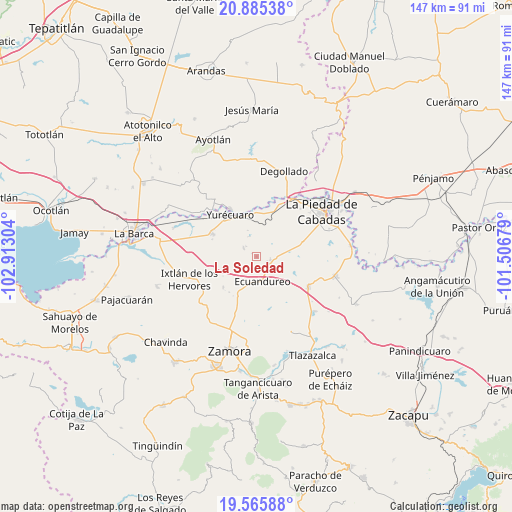
La Soledad GPS coordinates[2]
20° 13' 37.308" North, 102° 12' 35.676" West
| Map corner | latitude | longitude |
|---|---|---|
| Upper-left | 20.88538°, | -102.91304° |
| Center: | 20.22703°, | -102.20991° |
| Lower-right: | 19.56588°, | -101.50679° |
| Map W x H: | 146.7×146.7 km | = 91.2×91.2mi |
| max Lat: | 32.7° ⇑38% North |
| La Soledad: | 20.22703° |
| min Lat: | ⇓62% South 14.53588° |
| min Long | La Soledad | max Long |
| -117.105° | -102.20991° | -86.73105° |
| W 17.9%⇐ | ⇒82.1% E |
Elevation
Elevation of La Soledad is 1551 m = 5089 ft, and this is 297.3 m = 975 ft above average elevation for this country.
| Max E: |
3497 m = 11473 ft | 46.5% |
| La Soledad | 1551 m 5089 ft | |
| Avg. | 1253.7 m = 4113 ft | |
Min E: |
-1 m = -3 ft | 53.5% |
See also: Mexico elevation on elevation.city.
Geographical zone
La Soledad is located in North Torrid zone (between Equator and Tropic of Cancer). Distance of this Northern Tropic circle is 356.9 km =221.8 mi to North.| Distance of | km | miles | from La Soledad |
|---|---|---|---|
| North Pole | 7758 | 4820.6 | to North |
| Arctic Circle | 5152.1 | 3201.4 | to North |
| Tropic Cancer | 356.9 | 221.8 | to North |
| Equator | 2249 | 1397.5 | to South |


Nearby cities:
15 places around La Soledad: (largest is in red/bold)
• Ecuandureo
7.4 km =4.6 mi,  166°
166°
• El Colesio
13 km =8.1 mi,  227°
227°
• El Refugio
6.2 km =3.9 mi,  339°
339°
• El Tequesquite
11.7 km =7.3 mi,  315°
315°
• La Noria
12.8 km =8 mi,  107°
107°
• Las Cieneguitas
4.4 km =2.7 mi,  303°
303°
• Las Fuentes
7.6 km =4.7 mi,  186°
186°
• Los Guajes
8.1 km =5 mi,  61°
61°
• Mirandillas
10.5 km =6.5 mi,  25°
25°
• Monteleón
9.1 km =5.7 mi,  1°
1°
• Rincón Grande
4.1 km =2.5 mi,  102°
102°
• Tanhuato de Guerrero
14.2 km =8.8 mi, 297°
• Tarimoro
13.2 km =8.2 mi,  275°
275°
• Tinaja de Vargas
9.2 km =5.7 mi,  256°
256°
• Ucácuaro
8.7 km =5.4 mi,  201°
201°
Sources, notices
• [Note1] Compared only with cities in Mexico existing in our database
• [Src1] Map data: © OpenStreetMap contributors (CC-BY-SA)
• [Src2] Other city data from geonames.org with taken over terms of usage.
• [Src3] Geographical zone / Annual Mean Temperature by Robert A. Rohde @ Wikipedia
