Monteleón geodata
Monteleón (Michoacán) is a populated place; located in Mexico in America/Mexico_City (GMT-6) time zone. With population of 1,259 people, there are 6874 cities with bigger population in this country. Compared to other cities in Mexico, 63.7% of cities are located further ↓South; 82.1% of cities are located further →East and 54.3% of cities have lower elevation than Monteleón. Note1


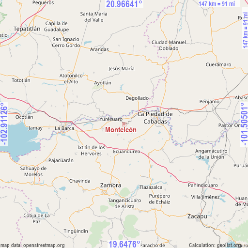
Monteleón GPS coordinates[2]
20° 18' 30.276" North, 102° 12' 29.268" West
| Map corner | latitude | longitude |
|---|---|---|
| Upper-left | 20.96641°, | -102.91126° |
| Center: | 20.30841°, | -102.20813° |
| Lower-right: | 19.6476°, | -101.50501° |
| Map W x H: | 146.6×146.6 km | = 91.1×91.1mi |
| max Lat: | 32.7° ⇑36.3% North |
| Monteleón: | 20.30841° |
| min Lat: | ⇓63.7% South 14.53588° |
| min Long | Monteleón | max Long |
| -117.105° | -102.20813° | -86.73105° |
| W 17.9%⇐ | ⇒82.1% E |
Elevation
Elevation of Monteleón is 1569 m = 5148 ft, and this is 315.3 m = 1034 ft above average elevation for this country.
| Max E: |
3497 m = 11473 ft | 45.7% |
| Monteleón | 1569 m 5148 ft | |
| Avg. | 1253.7 m = 4113 ft | |
Min E: |
-1 m = -3 ft | 54.3% |
See also: Mexico elevation on elevation.city.
Geographical zone
Monteleón is located in North Torrid zone (between Equator and Tropic of Cancer). Distance of this Northern Tropic circle is 347.8 km =216.1 mi to North.| Distance of | km | miles | from Monteleón |
|---|---|---|---|
| North Pole | 7749 | 4815 | to North |
| Arctic Circle | 5143.1 | 3195.8 | to North |
| Tropic Cancer | 347.8 | 216.1 | to North |
| Equator | 2258.1 | 1403.1 | to South |


Nearby cities:
15 places around Monteleón: (largest is in red/bold)
• Buenos Aires
9 km =5.6 mi,  21°
21°
• El Castillo
6.7 km =4.2 mi,  353°
353°
• El Mezquite Grande
5.9 km =3.7 mi,  2°
2°
• El Refugio
4.1 km =2.5 mi,  216°
216°
• El Tequesquite
8.4 km =5.2 mi,  264°
264°
• La Concepción
13.5 km =8.4 mi,  290°
290°
• La Noria
14.1 km =8.8 mi,  301°
301°
• La Ribera
9 km =5.6 mi, 300°
• La Soledad
9.1 km =5.7 mi,  181°
181°
• Las Cieneguitas
7.7 km =4.8 mi,  210°
210°
• Los Guajes
8.7 km =5.4 mi,  127°
127°
• Mirandillas
4.4 km =2.7 mi,  84°
84°
• Rincón Grande
10.7 km =6.6 mi,  159°
159°
• Tanhuato de Guerrero
13.1 km =8.1 mi, 258°
• Yurécuaro
8.5 km =5.3 mi, 291°
Sources, notices
• [Note1] Compared only with cities in Mexico existing in our database
• [Src1] Map data: © OpenStreetMap contributors (CC-BY-SA)
• [Src2] Other city data from geonames.org with taken over terms of usage.
• [Src3] Geographical zone / Annual Mean Temperature by Robert A. Rohde @ Wikipedia
