Las Ánimas geodata
Las Ánimas (Aguascalientes) is a populated place; located in Mexico in America/Mexico_City (GMT-6) time zone. With population of 1,794 people, there are 4848 cities with bigger population in this country. Compared to other cities in Mexico, 84.7% of cities are located further ↓South; 82.5% of cities are located further →East and 68.2% of cities have lower elevation than Las Ánimas. Note1


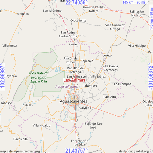
Las Ánimas GPS coordinates[2]
22° 5' 26.052" North, 102° 16' 0.624" West
| Map corner | latitude | longitude |
|---|---|---|
| Upper-left | 22.74056°, | -102.96997° |
| Center: | 22.09057°, | -102.26684° |
| Lower-right: | 21.43757°, | -101.56372° |
| Map W x H: | 144.9×144.9 km | = 90×90mi |
| max Lat: | 32.7° ⇑15.3% North |
| Las Ánimas: | 22.09057° |
| min Lat: | ⇓84.7% South 14.53588° |
| min Long | Las Ánimas | max Long |
| -117.105° | -102.26684° | -86.73105° |
| W 17.5%⇐ | ⇒82.5% E |
Elevation
Elevation of Las Ánimas is 1893 m = 6211 ft, and this is 639.3 m = 2097 ft above average elevation for this country.
| Max E: |
3497 m = 11473 ft | 31.8% |
| Las Ánimas | 1893 m 6211 ft | |
| Avg. | 1253.7 m = 4113 ft | |
Min E: |
-1 m = -3 ft | 68.2% |
See also: Mexico elevation on elevation.city.
Geographical zone
Las Ánimas is located in North Torrid zone (between Equator and Tropic of Cancer). Distance of this Northern Tropic circle is 149.7 km =93 mi to North.| Distance of | km | miles | from Las Ánimas |
|---|---|---|---|
| North Pole | 7550.8 | 4691.8 | to North |
| Arctic Circle | 4944.9 | 3072.6 | to North |
| Tropic Cancer | 149.7 | 93 | to North |
| Equator | 2456.2 | 1526.2 | to South |


Nearby cities:
15 places around Las Ánimas: (largest is in red/bold)
• Chicalote
8.9 km =5.5 mi,  170°
170°
• El Refugio
9.8 km =6.1 mi,  24°
24°
• Emiliano Zapata
3.9 km =2.4 mi,  296°
296°
• La Concepción
7 km =4.3 mi,  209°
209°
• La Escondida
6.1 km =3.8 mi, 172°
• Las Jaulas
9.2 km =5.7 mi, 206°
• Loretito (Charco del Toro)
10.1 km =6.3 mi, 166°
• Ojo Zarco
3.3 km =2.1 mi,  52°
52°
• Pabellón de Arteaga
6.3 km =3.9 mi,  350°
350°
• Paseos de la Providencia [Fraccionamiento]
7.4 km =4.6 mi,  188°
188°
• San Francisco de los Romo
1.5 km =0.9 mi,  197°
197°
• San Luis de Letras
5.9 km =3.7 mi,  327°
327°
• Santa Isabel [Fraccionamiento]
1.1 km =0.7 mi, 185°
• Santiago
8 km =5 mi,  293°
293°
• Valladolid
9.2 km =5.7 mi, 212°
Sources, notices
• [Note1] Compared only with cities in Mexico existing in our database
• [Src1] Map data: © OpenStreetMap contributors (CC-BY-SA)
• [Src2] Other city data from geonames.org with taken over terms of usage.
• [Src3] Geographical zone / Annual Mean Temperature by Robert A. Rohde @ Wikipedia
