La Calle geodata
La Calle (State of Mexico) is a populated place; located in Mexico in America/Mexico_City (GMT-6) time zone. With population of 1,580 people, there are 5466 cities with bigger population in this country. Compared to other cities in Mexico, 63.2% of cities are located further ↓South; 78.5% of cities are located further →East and 58.6% of cities have lower elevation than La Calle. Note1


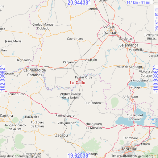
La Calle GPS coordinates[2]
20° 17' 10.608" North, 101° 38' 12.444" West
| Map corner | latitude | longitude |
|---|---|---|
| Upper-left | 20.94438°, | -102.33992° |
| Center: | 20.28628°, | -101.63679° |
| Lower-right: | 19.62538°, | -100.93367° |
| Map W x H: | 146.7×146.7 km | = 91.2×91.2mi |
| max Lat: | 32.7° ⇑36.8% North |
| La Calle: | 20.28628° |
| min Lat: | ⇓63.2% South 14.53588° |
| min Long | La Calle | max Long |
| -117.105° | -101.63679° | -86.73105° |
| W 21.5%⇐ | ⇒78.5% E |
Elevation
Elevation of La Calle is 1702 m = 5584 ft, and this is 448.3 m = 1471 ft above average elevation for this country.
| Max E: |
3497 m = 11473 ft | 41.4% |
| La Calle | 1702 m 5584 ft | |
| Avg. | 1253.7 m = 4113 ft | |
Min E: |
-1 m = -3 ft | 58.6% |
See also: Mexico elevation on elevation.city.
Geographical zone
La Calle is located in North Torrid zone (between Equator and Tropic of Cancer). Distance of this Northern Tropic circle is 350.3 km =217.7 mi to North.| Distance of | km | miles | from La Calle |
|---|---|---|---|
| North Pole | 7751.4 | 4816.5 | to North |
| Arctic Circle | 5145.6 | 3197.3 | to North |
| Tropic Cancer | 350.3 | 217.7 | to North |
| Equator | 2255.6 | 1401.6 | to South |


Nearby cities:
15 places around La Calle: (largest is in red/bold)
• Atarjea de Crucitas
3.3 km =2.1 mi,  345°
345°
• Cerritos de Aceves
5 km =3.1 mi,  23°
23°
• El Arco
7.6 km =4.7 mi,  118°
118°
• El Varal
7.9 km =4.9 mi,  28°
28°
• Gildardo Magaña
5.8 km =3.6 mi,  192°
192°
• La Calera (Nacimientos)
6.5 km =4 mi,  100°
100°
• Los Corrales
7.5 km =4.7 mi,  64°
64°
• Maritas
5 km =3.1 mi,  48°
48°
• Noria de Barajas
6.4 km =4 mi,  330°
330°
• Ordeñita de Barajas
7.9 km =4.9 mi, 330°
• Pastor Ortíz
4.8 km =3 mi, 63°
• Potreros
4.2 km =2.6 mi,  211°
211°
• Rincón de Martínez
7.7 km =4.8 mi, 52°
• Tres Mezquites
2.9 km =1.8 mi,  159°
159°
• Zapote de Parras
5.2 km =3.2 mi, 185°
Sources, notices
• [Note1] Compared only with cities in Mexico existing in our database
• [Src1] Map data: © OpenStreetMap contributors (CC-BY-SA)
• [Src2] Other city data from geonames.org with taken over terms of usage.
• [Src3] Geographical zone / Annual Mean Temperature by Robert A. Rohde @ Wikipedia
